Approximate Location Map
Large Map »
Latitude: 51.2652 / 51°15'54"N
Longitude: 0.4095 / 0°24'34"E
OS Eastings: 568200
OS Northings: 154542
OS Grid: TQ682545
Mapcode National: GBR NPR.NC4
Mapcode Global: VHJMC.1GVF
Plus Code: 9F327C85+3R
Entry Name: Barn 40 Yards West of Great Canon Court
Listing Date: 19 April 1985
Grade: II
Source: Historic England
Source ID: 1319958
English Heritage Legacy ID: 178912
ID on this website: 101319958
Location: Tonbridge and Malling, Kent, ME18
County: Kent
District: Tonbridge and Malling
Town: Tonbridge and Malling
Civil Parish: Wateringbury
Traditional County: Kent
Lieutenancy Area (Ceremonial County): Kent
Church of England Parish: Wateringbury St John the Baptist
Church of England Diocese: Rochester
Tagged with: Barn
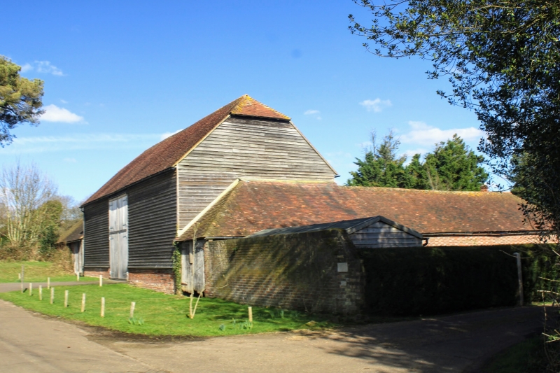
TQ 65 SE WATERINGBURY CANON LANE
(east side)
2/76 Barn 40 yards west of
Great Canon Court
-
GV II
Barn C19. Weather-boarded with gabled plain tile roof and catslide to east.
Central wagon entrance. 5 bays. Included for group value only.
Listing NGR: TQ6820054542
External links are from the relevant listing authority and, where applicable, Wikidata. Wikidata IDs may be related buildings as well as this specific building. If you want to add or update a link, you will need to do so by editing the Wikidata entry.


Other nearby listed buildings
