Approximate Location Map
Large Map »
Latitude: 51.2504 / 51°15'1"N
Longitude: 0.3553 / 0°21'19"E
OS Eastings: 564473
OS Northings: 152770
OS Grid: TQ644527
Mapcode National: GBR NPW.DPQ
Mapcode Global: VHJMB.3TQT
Plus Code: 9F327924+54
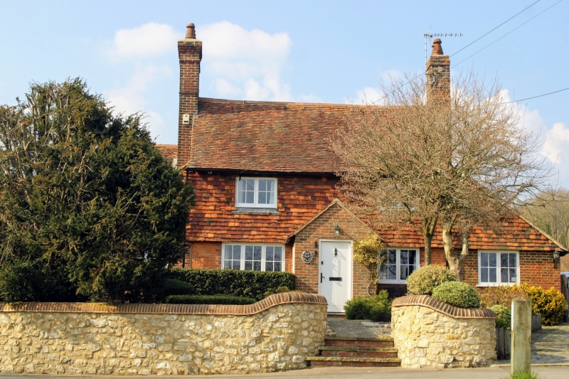
Entry Name: The Forge House
Listing Date: 19 April 1985
Grade: II
Source: Historic England
Source ID: 1115781
English Heritage Legacy ID: 178953
ID on this website: 101115781
Location: West Peckham, Tonbridge and Malling, Kent, ME18
County: Kent
District: Tonbridge and Malling
Civil Parish: West Peckham
Traditional County: Kent
Lieutenancy Area (Ceremonial County): Kent
Church of England Parish: West Peckham St Dunstan
Church of England Diocese: Rochester
Tagged with: House
TQ 65 SW WEST PECKHAM FORGE LANE (north
side)
1/19 The Forge House
- II
Cottage C18. Red brick ground-floor, tile-hung 1st floor. Plain tiled roof
with catslide to rear. 2 storeys, 2 windows, casements. Central boarded door
with tiled hood. Lean to addition to left.
Listing NGR: TQ6435352745
External links are from the relevant listing authority and, where applicable, Wikidata. Wikidata IDs may be related buildings as well as this specific building. If you want to add or update a link, you will need to do so by editing the Wikidata entry.


Other nearby listed buildings
