Approximate Location Map
Large Map »
Latitude: 51.2449 / 51°14'41"N
Longitude: 0.3332 / 0°19'59"E
OS Eastings: 562945
OS Northings: 152106
OS Grid: TQ629521
Mapcode National: GBR NPV.T8D
Mapcode Global: VHHPV.QZH2
Plus Code: 9F3268VM+W7
Entry Name: The Dower House
Listing Date: 19 April 1985
Grade: II
Source: Historic England
Source ID: 1070647
English Heritage Legacy ID: 178976
ID on this website: 101070647
Location: Tonbridge and Malling, Kent, TN11
County: Kent
District: Tonbridge and Malling
Civil Parish: West Peckham
Traditional County: Kent
Lieutenancy Area (Ceremonial County): Kent
Church of England Parish: West Peckham St Dunstan
Church of England Diocese: Rochester
Tagged with: House
TQ 65 SW WEST PECKHAM SCHOOL ROAD (South
side)
1/12
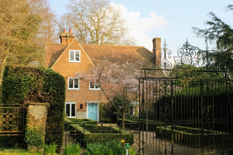
- The Dower House
- II
House, C17 possibly part of the outbuildings of the early C17 Oxon Hoath. Red brick
with tiled roof, half-hipped to south. L-shaped in plan with gables to north
and east, and ridge stack to east. 2 storeys and attic, 3 windows front to east,
modern easements. Central door with bracketed hood.
Listing NGR: TQ6294552106
External links are from the relevant listing authority and, where applicable, Wikidata. Wikidata IDs may be related buildings as well as this specific building. If you want to add or update a link, you will need to do so by editing the Wikidata entry.


Other nearby listed buildings
