Approximate Location Map
Large Map »
Latitude: 51.3034 / 51°18'12"N
Longitude: 0.4718 / 0°28'18"E
OS Eastings: 572403
OS Northings: 158931
OS Grid: TQ724589
Mapcode National: GBR PQS.63F
Mapcode Global: VHJM6.4H9P
Plus Code: 9F328F3C+9P
Entry Name: Gatehouse and Walls to the North and East of the Friars
Listing Date: 25 February 1987
Grade: I
Source: Historic England
Source ID: 1111775
English Heritage Legacy ID: 179203
ID on this website: 101111775
Location: Millhall, Tonbridge and Malling, Kent, ME20
County: Kent
District: Tonbridge and Malling
Civil Parish: Aylesford
Built-Up Area: Ditton
Traditional County: Kent
Lieutenancy Area (Ceremonial County): Kent
Church of England Parish: Aylesford St Peter and St Paul
Church of England Diocese: Rochester
Tagged with: Wall
AYLESFORD CP BULL LANE
TQ 7258 &
TQ 7259 (east side)
12/22 & 11/22 Gatehouse and walls to
the north and east of
- The Friars
GV I
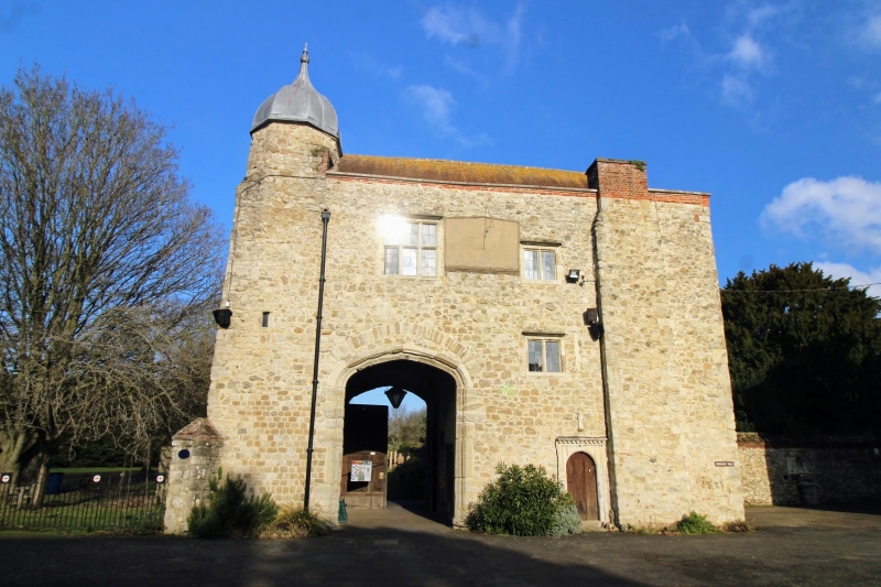
Gatehouse. C15 with late C16 alterations. Random rubble stone with parapet to
plain tiled roof. North side: Projecting breast off-centre to left, corbelled
out from 1st floor. 2 storeys; irregular 3-window 1st floor and 1 window ground
floor, lattice casement windows, those on 1st floor in chamfered mullioned and
transomed surrounds. Tall, wide entrance arch to right; moulded 4-centred arch
in square surround with relieving arch over. Cross-shaped loops to right and
left of arch, much weathered statue of Virgin, with Child over. Octagonal
stair-tower visible over parapet to left at rear. Pair of random stone walls
leading to north, either side of entrance road. Part brick-coped to right, all
between 8 and 12 feet high, and approximately 110 yards long. Random stone
brick coped wall to east of gatehouse, 70 yards long and 10 feet high. Pair of
brick piers towards left end, flanking entrance now partially blocked by C20
entrance insertion.
Listing NGR: TQ7242759011
External links are from the relevant listing authority and, where applicable, Wikidata. Wikidata IDs may be related buildings as well as this specific building. If you want to add or update a link, you will need to do so by editing the Wikidata entry.


Other nearby listed buildings
