Approximate Location Map
Large Map »
Latitude: 51.3025 / 51°18'8"N
Longitude: 0.3924 / 0°23'32"E
OS Eastings: 566870
OS Northings: 158644
OS Grid: TQ668586
Mapcode National: GBR NPB.B0H
Mapcode Global: VHJM4.RJ9D
Plus Code: 9F32892R+XX
Entry Name: Milestone
Listing Date: 25 February 1987
Grade: II
Source: Historic England
Source ID: 1363151
English Heritage Legacy ID: 179382
ID on this website: 101363151
Location: New Town, Tonbridge and Malling, Kent, ME19
County: Kent
District: Tonbridge and Malling
Civil Parish: Ryarsh
Built-Up Area: West Malling
Traditional County: Kent
Lieutenancy Area (Ceremonial County): Kent
Church of England Parish: Ryarsh St Martin
Church of England Diocese: Rochester
Tagged with: Milestone
RYARSH CP LONDON ROAD
TQ 65 NE
(north side)
7/206
- Milestone
- II
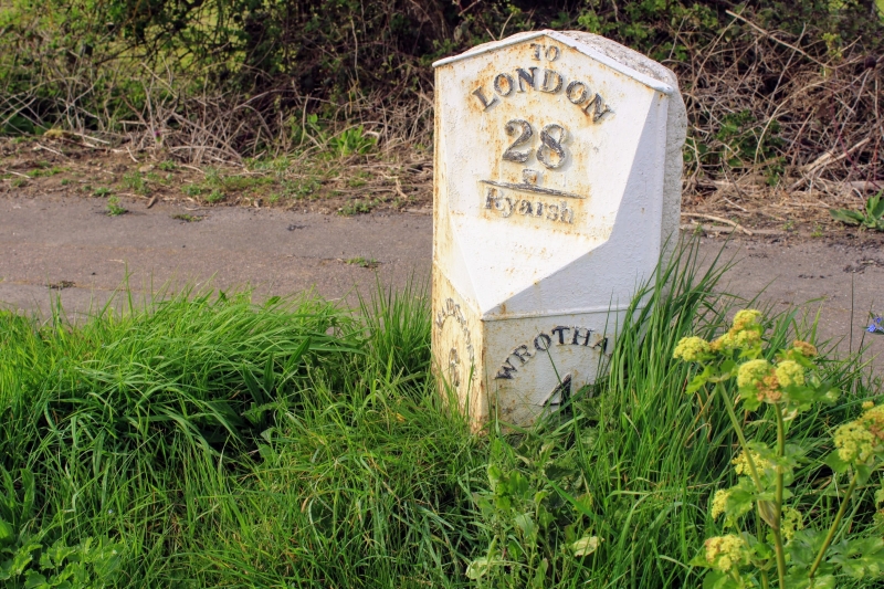
Milestone. Mid Cl9. Cast-iron. Square becoming diamond shape towards sheared
top. Raised lettering:-
'TO LONDON 28 - RYARSH above
'MAIDSTONE 6 - WROTHAM 4' below.
Listing NGR: TQ6745758611
External links are from the relevant listing authority and, where applicable, Wikidata. Wikidata IDs may be related buildings as well as this specific building. If you want to add or update a link, you will need to do so by editing the Wikidata entry.


Other nearby listed buildings
