Approximate Location Map
Large Map »
Latitude: 51.2909 / 51°17'27"N
Longitude: 0.4313 / 0°25'52"E
OS Eastings: 569624
OS Northings: 157449
OS Grid: TQ696574
Mapcode National: GBR NPL.1VB
Mapcode Global: VHJM5.FTC8
Plus Code: 9F327CRJ+9G
Entry Name: Blackland Timber Barn
Listing Date: 22 January 1992
Grade: II
Source: Historic England
Source ID: 1070458
English Heritage Legacy ID: 179435
ID on this website: 101070458
Location: Mill Street, Tonbridge and Malling, Kent, ME19
County: Kent
District: Tonbridge and Malling
Civil Parish: East Malling and Larkfield
Built-Up Area: Ditton
Traditional County: Kent
Lieutenancy Area (Ceremonial County): Kent
Church of England Parish: East Malling St James
Church of England Diocese: Rochester
Tagged with: Building
The following building shall be added to the list:-
EAST MALLING & LARKFIELD BLACKLANDS
TQ 65 NE
7/10000 Blackland Timber Barn
(formerly KCC Depot)
GV II
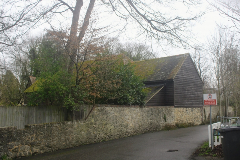
Barn and other agricultural buildings. Late C18, shown on Ordnance
Survey map of 1789 and formerly farm buildings to Clare Farm. L-shaped
range. Central barn is timber framed, clad in wide tarred weather-
boarding. Half-hipped tiled roof. Double cart door. 4-bay barn with
inserted floor and wall frame with diagonal braces. To SW is 2-storey
range, ground floor ragstone, 1st floor weatherboarded. Tiled roof.
1st floor has 3-plank loading door. Ground floor has 3 openings with
brick surrounds and iron bars. To NE is a similar 2-storey range of
identical materials with loading door to 1st floor and 2 openings with
iron bars. L-wing attached to NE has front of red brick with grey
headers and 1st floor weatherboarded and rear of Kentish ragstone.
Tiles missing from roof at time of survey. Roof has through purlins,
collar beam and queen struts.
At one time there was a cottage to the south east but this has since
been demolished.
Listing NGR: TQ6962457449
External links are from the relevant listing authority and, where applicable, Wikidata. Wikidata IDs may be related buildings as well as this specific building. If you want to add or update a link, you will need to do so by editing the Wikidata entry.


Other nearby listed buildings
