Approximate Location Map
Large Map »
Latitude: 51.2234 / 51°13'24"N
Longitude: 0.3352 / 0°20'6"E
OS Eastings: 563160
OS Northings: 149729
OS Grid: TQ631497
Mapcode National: GBR NQ7.7KR
Mapcode Global: VHHQ1.RHKZ
Plus Code: 9F3268FP+93
Entry Name: Oasthouse Approximately 8 Metres North West of Spring House
Listing Date: 19 February 1990
Grade: II
Source: Historic England
Source ID: 1264209
English Heritage Legacy ID: 179513
ID on this website: 101264209
Location: Hadlow, Tonbridge and Malling, Kent, TN11
County: Kent
District: Tonbridge and Malling
Civil Parish: Hadlow
Built-Up Area: Hadlow
Traditional County: Kent
Lieutenancy Area (Ceremonial County): Kent
Church of England Parish: Hadlow
Church of England Diocese: Rochester
Tagged with: Drying house
HADLOW HIGH STREET (north side)
TQ 63 49
7/77 Oasthouse approx 8m north
- west of Spring House
GV II
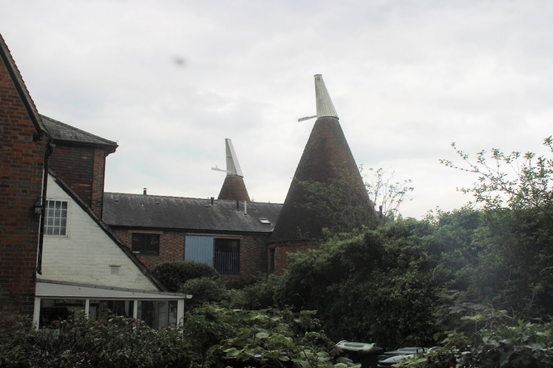
Disused oasthouse. Mid/late C19, some early C20 alterations. Flemish bond
brick with burnt headers used decoratively in places; kilns have peg-tile
roofs, stowage roof replaced with corrugated asbestos.
Plan: The stowage is on a north south axis facing west. Circular hop kilns
on the 2 left (northern) end corners. Stowage extended northwards in early
C20. 2 storeys with integral lean-to outshot on south end.
Exterior: The eastern front of the stowage has a ground floor garage-size
doorway at ground floor with a window to left and loading hatch doorway to
right at first floor. All these openings have been rebuilt in the C20. The
window like others around the stowage is iron-framed with glazing bars. Both
sections of the stowage roof are gable-ended. The hop kilns have a corbelled
cornice including a dentil band of burnt headers. Tall conical roofs. Only
the western kiln still has a cowl.
Interior: Not inspected.
This oasthouse, along with the nearby Maltings (q.v.), plays an important
visual role on the western approach to Hadlow. They also indicate the
historic importance of brewing to the local economy.
Listing NGR: TQ6316049729
External links are from the relevant listing authority and, where applicable, Wikidata. Wikidata IDs may be related buildings as well as this specific building. If you want to add or update a link, you will need to do so by editing the Wikidata entry.


Other nearby listed buildings
