Approximate Location Map
Large Map »
Latitude: 51.2237 / 51°13'25"N
Longitude: 0.2575 / 0°15'26"E
OS Eastings: 557734
OS Northings: 149590
OS Grid: TQ577495
Mapcode National: GBR MNS.CWJ
Mapcode Global: VHHQ0.DHZR
Plus Code: 9F3267F4+FX
Entry Name: Trench Farmhouse
Listing Date: 19 February 1990
Grade: II
Source: Historic England
Source ID: 1363163
English Heritage Legacy ID: 179550
ID on this website: 101363163
Location: Coldharbour, Tonbridge and Malling, Kent, TN11
County: Kent
District: Tonbridge and Malling
Civil Parish: Hildenborough
Traditional County: Kent
Lieutenancy Area (Ceremonial County): Kent
Church of England Parish: Hildenborough St John the Evangelist
Church of England Diocese: Rochester
Tagged with: Farmhouse
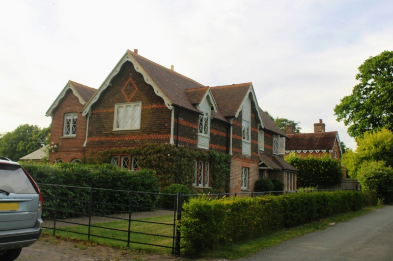
HILDENBOROUGH COLDHARBOUR LANE (west side)
TQ 54 NE
5/113 Trench Farmhouse
GV II
Farmhouse. Probably late 1830s/early 1840s; said to be shown on the tithe map
(information from the owner), although some of the external detail looks
later. Ground floor brick, first floor tile-hung including bands of scalloped
tiles and diapering; peg-tile roof with C19 crested ridge tiles; brick stacks.
Plan: East-facing, overlooking Coldharbour Lane. Double depth plan under a
2-span roof; entrance to right of centre, facing the stair.
Exterior: 2 storeys. Asymmetrical 4-bay east elevation. Gable-ended roof;
decorative brick band below tile-hanging. The bay from the left is broken
forward and gabled to the front with deep verges and pierced curly
bargeboards. Porch alongside to the right with a lean-to roof carried across
the C20 front door as a pentice, ground floor bay to the right with a hipped
roof. Striking 1-, 2- and 3-light casement windows, 2 panes per light, each
pane subdivided into 4 by diagonal glazing bars. The first floor window in
the projecting bay is set in a vertical panel with rectangles of roughcast
with incised diagonal decoration.. First floor window left is a gabled dormer
with matching bargeboards and a matching vertical panel of rendered
decoration. Matching bargeboards to the gable ends of the main roof. The
left return and rear elevation have round headed brick openings on the ground
floor.
Interior: Not inspected.
A roadside house with some unusual external detail.
Listing NGR: TQ5773449590
External links are from the relevant listing authority and, where applicable, Wikidata. Wikidata IDs may be related buildings as well as this specific building. If you want to add or update a link, you will need to do so by editing the Wikidata entry.


Other nearby listed buildings
