Approximate Location Map
Large Map »
Latitude: 51.2318 / 51°13'54"N
Longitude: 0.213 / 0°12'46"E
OS Eastings: 554599
OS Northings: 150398
OS Grid: TQ545503
Mapcode National: GBR MNK.LPJ
Mapcode Global: VHHPZ.M9YJ
Plus Code: 9F3266J7+P5
Entry Name: The Lodge, Nizels
Listing Date: 19 February 1990
Grade: II
Source: Historic England
Source ID: 1070402
English Heritage Legacy ID: 179595
ID on this website: 101070402
Location: Tonbridge and Malling, Kent, TN11
County: Kent
District: Tonbridge and Malling
Civil Parish: Hildenborough
Traditional County: Kent
Lieutenancy Area (Ceremonial County): Kent
Church of England Parish: Hildenborough St John the Evangelist
Church of England Diocese: Rochester
Tagged with: Building
HILDENBOROUGH NIZELS LANE (west side)
TQ 55 SW
1/162 The Lodge, Nizels
-
GV II
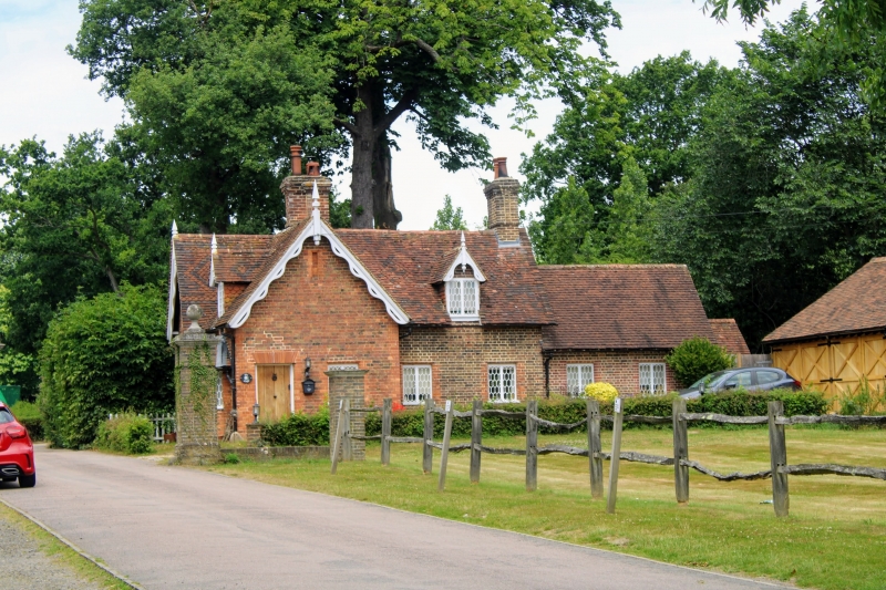
Lodge to Nizels House (q.v.). Circa 1840s, possibly enlarged in the late
C19/early C20. The north block is English bond brick, the south block Flemish
bond; peg-tile roof with ornamental diamond patterns; 2 brick stacks. Tudor
style.
Plan and Development: Overall T plan. The Lodge faces south, overlooking the
drive to Nizels House with a canted bay observation window. Entrance on the
east elevation. The building consists of 2 blocks at right angles, the north
block, judging from the brickwork, may be earlier; if so, the south block has
been carefully designed to match it. There is a stack at the north end of the
north block and an axial stack at the junction between the north and south
blocks. There is a C20 single-storey flat-roofed addition at right angles to
the north block on the west side.
Exterior: Very unspoiled externally with curly pierced bargeboards with
pendants and finials to all the gables and a complete set of C19 2-light iron
casements with sexagonal panes. 2 storeys. Asymmetrical 1:1 window south
elevation, slightly projecting and gabled to the front at the left (west). To
the right there is a canted bay to the ground floor with a pyramidal roof with
fish-scale tiles below a gabled dormer. 1:2 east elevation, the projecting
gabled end of the south block to the left with a C20 door below a rubbed brick
flat arch with a window alongside to the right. The east front of the north
block, to the right has 2 ground floor casements and a gabled dormer. The
rear (west) elevation of the north block also preserves a gabled dormer with
curly bargeboards and an original window.
Interior: Not inspected.
Group value with the gate piers and gate (q.v.) at the entrance to the drive
to Nizels House.
Listing NGR: TQ5467849570
External links are from the relevant listing authority and, where applicable, Wikidata. Wikidata IDs may be related buildings as well as this specific building. If you want to add or update a link, you will need to do so by editing the Wikidata entry.


Other nearby listed buildings
