Approximate Location Map
Large Map »
Latitude: 51.2104 / 51°12'37"N
Longitude: 0.2298 / 0°13'47"E
OS Eastings: 555849
OS Northings: 148047
OS Grid: TQ558480
Mapcode National: GBR MNY.4WP
Mapcode Global: VHHPZ.XVV0
Plus Code: 9F32666H+4W
Entry Name: Stable About 25 Metres West of Old Barn Farmhouse
Listing Date: 19 February 1990
Grade: II
Source: Historic England
Source ID: 1070378
English Heritage Legacy ID: 179640
ID on this website: 101070378
Location: Stocks Green, Tonbridge and Malling, Kent, TN11
County: Kent
District: Tonbridge and Malling
Civil Parish: Hildenborough
Traditional County: Kent
Lieutenancy Area (Ceremonial County): Kent
Church of England Parish: Hildenborough St John the Evangelist
Church of England Diocese: Rochester
Tagged with: Stable
HILDENBOROUGH STOCKS GREEN ROAD
TQ 54 NE
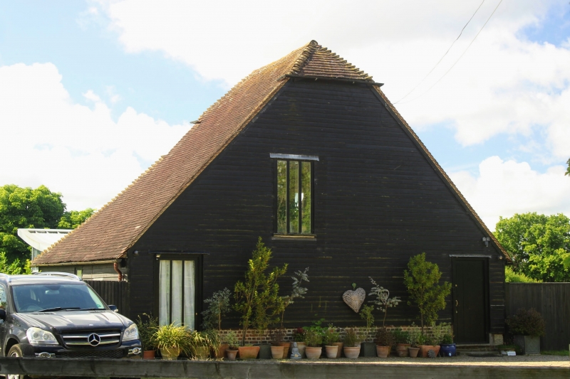
5/207 Stable about 25m west of
- Old Barn Farmhouse
II
Stable with loft over. Probably late C17. Framed construction, clad in
weatherboarding; tile roof, half-hipped at north end, gabletted at south end.
Plan: Built on a north-south axis. Rectangular on plan with west and east
outshuts with a longitudinal partition dividing the ground floor between 2
sets of stables, each with a door in the north end. The very tall loft has
gaps in the floor to either side of the central partition in the stable to
allow fodder to be dropped into the mangers. Outshut at south end.
Exterior: Roof gabletted at north and south ends and swept down as a catslide
to the east and west outshuts. 2 doorways and a loft door in the north end, 3
windows on east side.
Interior: Original carpentry, the outshut catslides carried on rather awkward
straight braces fixed to joists in the loft floor.
Group value with the tea room complex.
Listing NGR: TQ5705648135
External links are from the relevant listing authority and, where applicable, Wikidata. Wikidata IDs may be related buildings as well as this specific building. If you want to add or update a link, you will need to do so by editing the Wikidata entry.


Other nearby listed buildings
