Approximate Location Map
Large Map »
Latitude: 51.2445 / 51°14'40"N
Longitude: 0.2208 / 0°13'14"E
OS Eastings: 555103
OS Northings: 151824
OS Grid: TQ551518
Mapcode National: GBR MNC.W3B
Mapcode Global: VHHPS.SZ2B
Plus Code: 9F3266VC+R8
Entry Name: Milking Parlour South West of Rumshed Farmhouse
Listing Date: 19 February 1990
Grade: II
Source: Historic England
Source ID: 1070380
English Heritage Legacy ID: 179647
ID on this website: 101070380
Location: Underriver, Sevenoaks, Kent, TN15
County: Kent
District: Sevenoaks
Civil Parish: Seal
Traditional County: Kent
Lieutenancy Area (Ceremonial County): Kent
Church of England Parish: Weald St George
Church of England Diocese: Rochester
Tagged with: Building
HILDENBOROUGH UNDERRIVER
TQ 55 SE
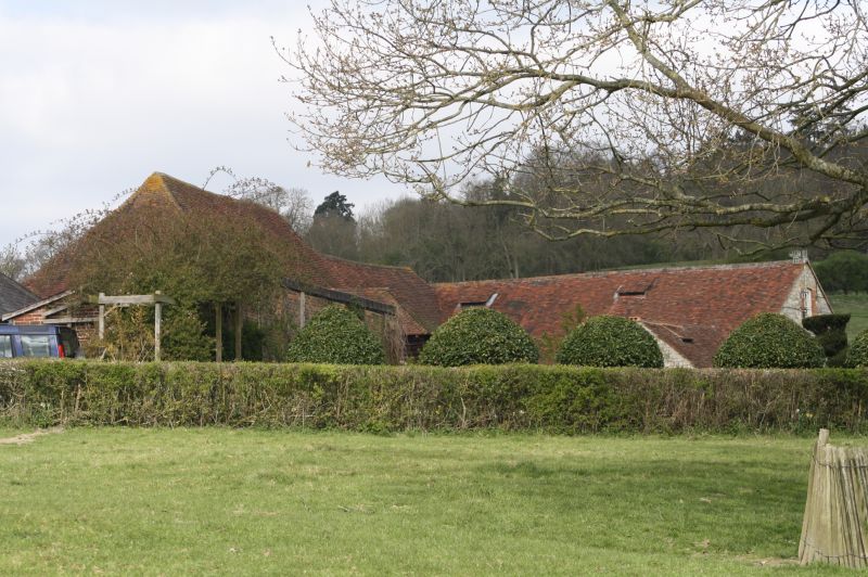
2/213 Milking parlour south west
of Rumshed Farmhouse
GV II
Milking parlour. Late C19. Ragstone rubble with brick dressings; peg-tile
roof.
Plan: On a north south axis and at right angles to the adjoining granary
(q.v.). A large rectangular milking parlour with a lean-to at the south end.
At the north end a small heated room adjoins at right angles to the east.
Entrances to the north and south ends.
Exterior: Single storey. Gabled roof. 4 windows to each long side with 4
original roof vents on each side of the ridge. The north end has a large C20
doorway in the centre flanked by smaller blocked doors. The heated room to
the left has a doorway on the north side, a stack in the south west corner and
brick quoins.
Interior: 6 bays of iron roof trusses with cambered ties. It is said that
some of the milking equipment used to be slung over the trusses (information
from owner).
Part of a good farmstead group with other agricultural buildings and Rumshed
Farmhouse, which was called St Julian's Farm before 1975. The parish and
district boundary runs through the farmhouse, which is partly in Sevenoaks
District.
Listing NGR: TQ5661249320
External links are from the relevant listing authority and, where applicable, Wikidata. Wikidata IDs may be related buildings as well as this specific building. If you want to add or update a link, you will need to do so by editing the Wikidata entry.


Other nearby listed buildings
