Approximate Location Map
Large Map »
Latitude: 51.0711 / 51°4'16"N
Longitude: 0.6904 / 0°41'25"E
OS Eastings: 588581
OS Northings: 133643
OS Grid: TQ885336
Mapcode National: GBR QW3.MD1
Mapcode Global: FRA D6B9.2SV
Plus Code: 9F323MCR+F5
Entry Name: 25, Ashford Road
Listing Date: 8 April 1970
Grade: II
Source: Historic England
Source ID: 1070393
English Heritage Legacy ID: 179676
ID on this website: 101070393
Location: Tenterden, Ashford, Kent, TN30
County: Kent
District: Ashford
Civil Parish: Tenterden
Built-Up Area: Tenterden
Traditional County: Kent
Lieutenancy Area (Ceremonial County): Kent
Tagged with: Building
1.
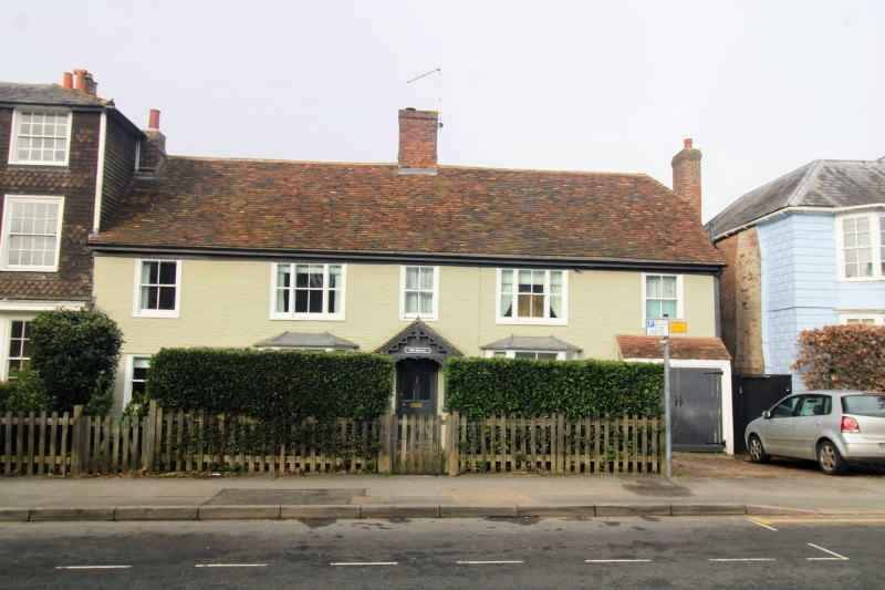
1715 ASHFORD ROAD
(North West Side)
No 25
TQ 8833 1/95 8.4.70.
II GV
2.
Late C18 or early C19. 2 storeys painted brick. Tiled roof. Eaves cornice.
5 sashes with glazing bars missing. 2 modern bay windows and a modern
gabled porch and garage cut into ground floor at north end.
Nos 21 to 27 (odd) form a group.
Listing NGR: TQ8858033638
External links are from the relevant listing authority and, where applicable, Wikidata. Wikidata IDs may be related buildings as well as this specific building. If you want to add or update a link, you will need to do so by editing the Wikidata entry.


Other nearby listed buildings
