Approximate Location Map
Large Map »
Latitude: 51.0767 / 51°4'36"N
Longitude: 0.6939 / 0°41'38"E
OS Eastings: 588805
OS Northings: 134276
OS Grid: TQ888342
Mapcode National: GBR QW3.G7W
Mapcode Global: FRA D6B8.Q4Z
Plus Code: 9F323MGV+MH
Entry Name: Homewood
Listing Date: 8 May 1950
Grade: II
Source: Historic England
Source ID: 1363185
English Heritage Legacy ID: 179681
ID on this website: 101363185
Location: St Michaels, Ashford, Kent, TN30
County: Kent
District: Ashford
Civil Parish: Tenterden
Built-Up Area: Tenterden
Traditional County: Kent
Lieutenancy Area (Ceremonial County): Kent
Tagged with: Building
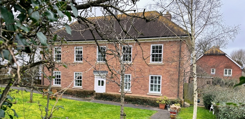
1.
1715 ASHFORD ROAD
(North West Side)
Homewood
TQ 83 SE 3/100 8.5.50.
II
2.
Dated l766 on the keystone of the doorway. Red brick. It consists of
a centre portion of 3 storeys and 5 windows and 2 modern wings in Neo-Georgian
style, of 2 storeys and 4 windows each with their ground floor recessed.
Hipped tiled roof with eaves cornice. Stringcourse above 1st floor.
Glazing bars intact. Rusticated doorcase with pediment, keystone and 5
panel moulded door.
Listing NGR: TQ8880534276
External links are from the relevant listing authority and, where applicable, Wikidata. Wikidata IDs may be related buildings as well as this specific building. If you want to add or update a link, you will need to do so by editing the Wikidata entry.


Other nearby listed buildings
