Approximate Location Map
Large Map »
Latitude: 51.0679 / 51°4'4"N
Longitude: 0.6879 / 0°41'16"E
OS Eastings: 588417
OS Northings: 133283
OS Grid: TQ884332
Mapcode National: GBR QW3.SVX
Mapcode Global: FRA D6B9.7T5
Plus Code: 9F323M9Q+54
Entry Name: 1 and 3, Bell's Lane
Listing Date: 8 June 1972
Grade: II
Source: Historic England
Source ID: 1070358
English Heritage Legacy ID: 179688
ID on this website: 101070358
Location: Tenterden, Ashford, Kent, TN30
County: Kent
District: Ashford
Civil Parish: Tenterden
Built-Up Area: Tenterden
Traditional County: Kent
Lieutenancy Area (Ceremonial County): Kent
Tagged with: Building
1.
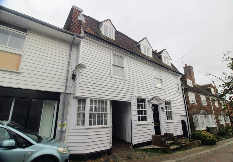
1715 BELL'S LANE
(North East Side)
Nos 1 & 3
TQ 8833 1/122
II GV
2.
2 small C18 houses with a passage through the centre. 2 storeys and attics,
fronted with weatherboarding. 1 hipped dormer to No 1 and bracket eaves
cornice. 3 sashes with some glazing bars missing. The doorcase is open
pedimented with pilasters and 6 flush panelled doors.
Nos 1 to 9 (odd) form a group.
Listing NGR: TQ8841733283
External links are from the relevant listing authority and, where applicable, Wikidata. Wikidata IDs may be related buildings as well as this specific building. If you want to add or update a link, you will need to do so by editing the Wikidata entry.


Other nearby listed buildings
