Approximate Location Map
Large Map »
Latitude: 51.0698 / 51°4'11"N
Longitude: 0.6901 / 0°41'24"E
OS Eastings: 588568
OS Northings: 133489
OS Grid: TQ885334
Mapcode National: GBR QW3.THZ
Mapcode Global: FRA D6B9.8P2
Plus Code: 9F323M9R+V2
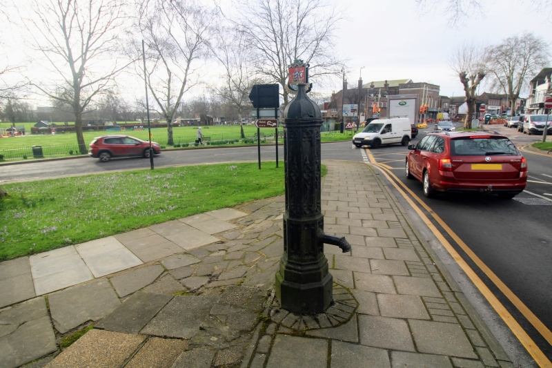
Entry Name: Drinking Fountain Situated on Edge of Green
Listing Date: 8 June 1972
Grade: II
Source: Historic England
Source ID: 1031817
English Heritage Legacy ID: 179702
ID on this website: 101031817
Location: Tenterden, Ashford, Kent, TN30
County: Kent
District: Ashford
Civil Parish: Tenterden
Built-Up Area: Tenterden
Traditional County: Kent
Lieutenancy Area (Ceremonial County): Kent
Tagged with: Drinking fountain
1.
1715 EAST CROSS
(East Side)
Drinking fountain situated
on edge of Green
TQ 8833 1/171
II
2.
Circa 1880. About 6 ft high. Octagonal with traceried sides and decorated
spout.
Listing NGR: TQ8856833489
External links are from the relevant listing authority and, where applicable, Wikidata. Wikidata IDs may be related buildings as well as this specific building. If you want to add or update a link, you will need to do so by editing the Wikidata entry.


Other nearby listed buildings
