Approximate Location Map
Large Map »
Latitude: 51.0681 / 51°4'4"N
Longitude: 0.6869 / 0°41'12"E
OS Eastings: 588347
OS Northings: 133292
OS Grid: TQ883332
Mapcode National: GBR QW3.SKV
Mapcode Global: FRA D6B9.7G4
Plus Code: 9F323M9P+6P
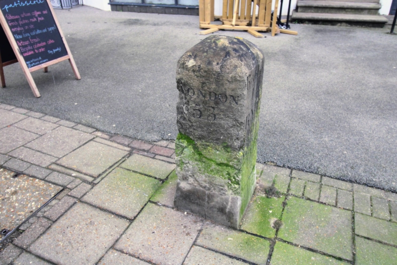
Entry Name: Milestone Opposite No 53
Listing Date: 8 June 1972
Grade: II
Source: Historic England
Source ID: 1363175
English Heritage Legacy ID: 179726
ID on this website: 101363175
Location: Tenterden, Ashford, Kent, TN30
County: Kent
District: Ashford
Civil Parish: Tenterden
Built-Up Area: Tenterden
Traditional County: Kent
Lieutenancy Area (Ceremonial County): Kent
Tagged with: Milestone
1.
1715 HIGH STREET
(South Side)
Milestone opposite No 53
TQ 8833 1/187
II GV
2.
C18. Stone. About 2 ft 6 ins high. To one side it has the inscription:-
"Romney 14: Rye 10: Ashford 12" - on the other side:- "Cranbrook 8:
Rolvenden 3." Formerly a Toll Gate crossed the street at this point with
a Toll House on the opposite side of the road.
All the listed buildings on the South side from Nos 17 to 57 form a group.
Listing NGR: TQ8834733292
External links are from the relevant listing authority and, where applicable, Wikidata. Wikidata IDs may be related buildings as well as this specific building. If you want to add or update a link, you will need to do so by editing the Wikidata entry.


Other nearby listed buildings
