Approximate Location Map
Large Map »
Latitude: 51.0672 / 51°4'1"N
Longitude: 0.6855 / 0°41'7"E
OS Eastings: 588256
OS Northings: 133195
OS Grid: TQ882331
Mapcode National: GBR QW9.04H
Mapcode Global: FRA D6B9.DWP
Plus Code: 9F323M8P+V6
Entry Name: 79-85, High Street
Listing Date: 8 April 1970
Grade: II
Source: Historic England
Source ID: 1363194
English Heritage Legacy ID: 179730
ID on this website: 101363194
Location: Tenterden, Ashford, Kent, TN30
County: Kent
District: Ashford
Civil Parish: Tenterden
Built-Up Area: Tenterden
Traditional County: Kent
Lieutenancy Area (Ceremonial County): Kent
Tagged with: Building
1.
1715 HIGH STREET
(South Side)
Nos 79 to 85 (odd)
TQ 8833 1/18 8.4.70.
II GV
2.
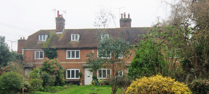
A row of late C17 or early C18 cottages. 2 storeys and attic. Red brick
with imitation quoins and painted stringcourse. 5 casements, those on
the ground floor with cambered head linings. Nos 79, 81 and 83 have original
windows with small square panes. 4 panel doors with flat hoods over.
Nos 79 to 117 (odd) form a group.
Listing NGR: TQ8825433191
External links are from the relevant listing authority and, where applicable, Wikidata. Wikidata IDs may be related buildings as well as this specific building. If you want to add or update a link, you will need to do so by editing the Wikidata entry.


Other nearby listed buildings
