Approximate Location Map
Large Map »
Latitude: 51.0669 / 51°4'0"N
Longitude: 0.6845 / 0°41'4"E
OS Eastings: 588188
OS Northings: 133161
OS Grid: TQ881331
Mapcode National: GBR QW8.5VJ
Mapcode Global: FRA D6B9.DHR
Plus Code: 9F323M8M+QR
Entry Name: 105 and 107, High Street
Listing Date: 8 May 1950
Grade: II
Source: Historic England
Source ID: 1070337
English Heritage Legacy ID: 179734
ID on this website: 101070337
Location: Tenterden, Ashford, Kent, TN30
County: Kent
District: Ashford
Civil Parish: Tenterden
Built-Up Area: Tenterden
Traditional County: Kent
Lieutenancy Area (Ceremonial County): Kent
Tagged with: Building
1.
1715 HIGH SWEET
(South Side)
Nos 105 & 107
TQ 8833 1/22 8.5.50.
II GV
2.
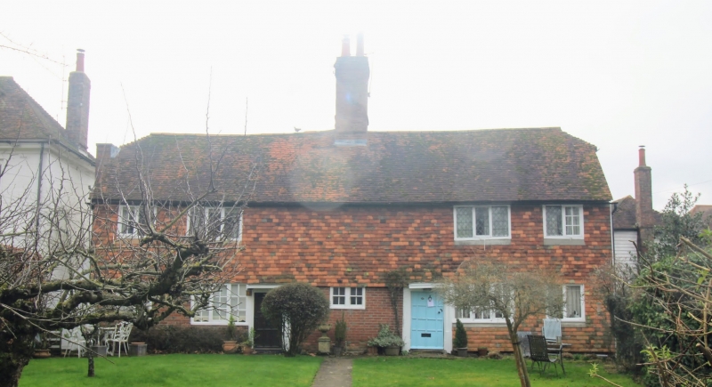
A pair of C17 timber-framed cottages. 2 storeys. Ground floor is faced
with mathematical tiles with grey headers, above tile-hung. Half-hipped
roof. Casement windows, some with original diamond panes. Doorcases with
flat hoods over: No 107 has an original door of 12 panels.
Nos 79 to 117 (odd) form a group.
Listing NGR: TQ8819233160
External links are from the relevant listing authority and, where applicable, Wikidata. Wikidata IDs may be related buildings as well as this specific building. If you want to add or update a link, you will need to do so by editing the Wikidata entry.


Other nearby listed buildings
