Approximate Location Map
Large Map »
Latitude: 51.0688 / 51°4'7"N
Longitude: 0.6881 / 0°41'17"E
OS Eastings: 588431
OS Northings: 133377
OS Grid: TQ884333
Mapcode National: GBR QW3.SY6
Mapcode Global: FRA D6B9.7X2
Plus Code: 9F323M9Q+G6
Entry Name: 22, High Street
Listing Date: 8 April 1970
Grade: II
Source: Historic England
Source ID: 1355061
English Heritage Legacy ID: 179745
ID on this website: 101355061
Location: Tenterden, Ashford, Kent, TN30
County: Kent
District: Ashford
Civil Parish: Tenterden
Built-Up Area: Tenterden
Traditional County: Kent
Lieutenancy Area (Ceremonial County): Kent
Tagged with: Building
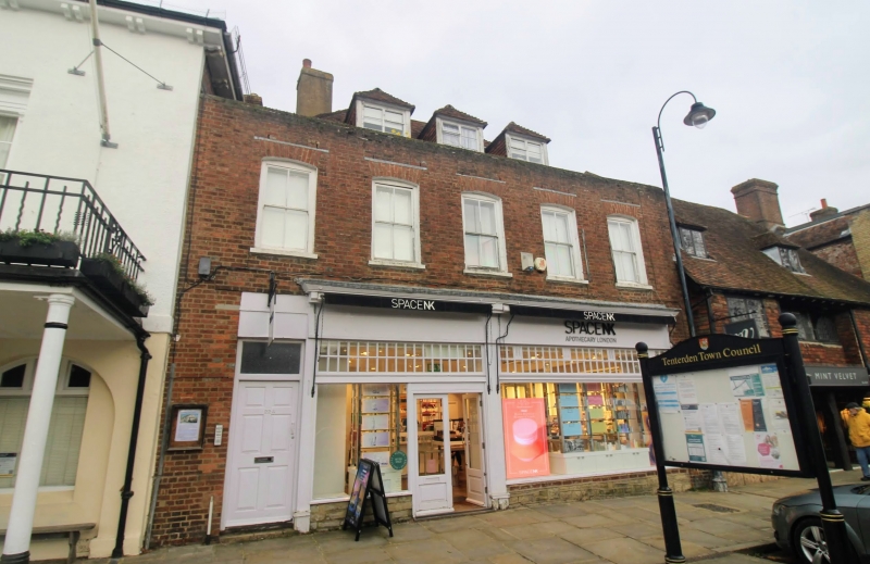
1.
1715 HIGH STREET
(North Side)
No 22
TQ 8833 1/33 8.4.70.
II GV
2.
C18. 2 storeys and attic red brick. 3 hipped dormers. 5 windows. 6-panel
moulded door at the west end of the front.
All the listed buildings on the north side from Nos 10 to 44, including
Church of St Mildred, form a group.
Listing NGR: TQ8843033390
External links are from the relevant listing authority and, where applicable, Wikidata. Wikidata IDs may be related buildings as well as this specific building. If you want to add or update a link, you will need to do so by editing the Wikidata entry.


Other nearby listed buildings
