Approximate Location Map
Large Map »
Latitude: 51.0673 / 51°4'2"N
Longitude: 0.6835 / 0°41'0"E
OS Eastings: 588114
OS Northings: 133200
OS Grid: TQ881332
Mapcode National: GBR QW8.5LQ
Mapcode Global: FRA D6B9.D3H
Plus Code: 9F323M8M+W9
Entry Name: 112 and 114, High Street
Listing Date: 8 May 1950
Grade: II
Source: Historic England
Source ID: 1281757
English Heritage Legacy ID: 179768
ID on this website: 101281757
Location: Tenterden, Ashford, Kent, TN30
County: Kent
District: Ashford
Civil Parish: Tenterden
Built-Up Area: Tenterden
Traditional County: Kent
Lieutenancy Area (Ceremonial County): Kent
Tagged with: Building
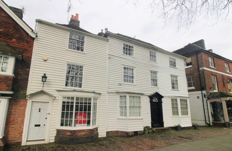
1.
1715 HIGH STREET
(North Side)
Nos 112 and 114
TQ 8833 1/53 8.5.50.
II GV
2.
Built as one house, now subdivided. C18. 3 storeys timber-framed.
Weatherboarded front. Hipped tiled roof with eaves cornice. 3 sashes with
glazing bars intact. 2 bay windows on the ground floor. Doorcase between
with pilasters, open pediment, semi-circular fanlight and 6 panelled door.
All the listed buildings on the north side from Nos 112 to 134 form a group.
Listing NGR: TQ8811433205
External links are from the relevant listing authority and, where applicable, Wikidata. Wikidata IDs may be related buildings as well as this specific building. If you want to add or update a link, you will need to do so by editing the Wikidata entry.


Other nearby listed buildings
