Approximate Location Map
Large Map »
Latitude: 51.0655 / 51°3'55"N
Longitude: 0.6812 / 0°40'52"E
OS Eastings: 587959
OS Northings: 132994
OS Grid: TQ879329
Mapcode National: GBR QW8.51T
Mapcode Global: FRA D699.K6H
Plus Code: 9F323M8J+6F
Entry Name: Tile Cottage
Listing Date: 8 May 1950
Grade: II
Source: Historic England
Source ID: 1071164
English Heritage Legacy ID: 179821
ID on this website: 101071164
Location: Tenterden, Ashford, Kent, TN30
County: Kent
District: Ashford
Civil Parish: Tenterden
Built-Up Area: Tenterden
Traditional County: Kent
Lieutenancy Area (Ceremonial County): Kent
Tagged with: Cottage
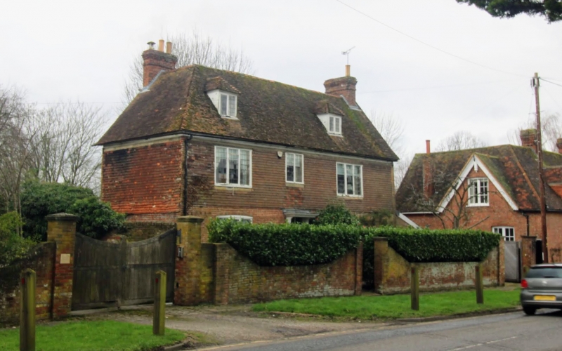
1.
1715 SMALLHYTHE ROAD
(West Side)
Tile Cottage
TQ 83 SE 3/69 8.5.50.
II GV
2.
C17. 2 storeys and attic. Ground floor red brick, above tile-hung. 2
dormers. 3 casement windows. 6-panel moulded door with rectangular fanlight
over. C19 gabled brick porch.
Tile Cottage and Garden Wall, and Chestnut House form a group.
Listing NGR: TQ8795932994
External links are from the relevant listing authority and, where applicable, Wikidata. Wikidata IDs may be related buildings as well as this specific building. If you want to add or update a link, you will need to do so by editing the Wikidata entry.


Other nearby listed buildings
