Approximate Location Map
Large Map »
Latitude: 51.0682 / 51°4'5"N
Longitude: 0.6846 / 0°41'4"E
OS Eastings: 588185
OS Northings: 133304
OS Grid: TQ881333
Mapcode National: GBR QW2.ZVT
Mapcode Global: FRA D6B9.6KC
Plus Code: 9F323M9M+7R
Entry Name: Derelict Industrial Building to Rear of No 82 Derelict Industrial Building to Rear of No 82 High Street
Listing Date: 8 June 1972
Grade: II
Source: Historic England
Source ID: 1281621
English Heritage Legacy ID: 179833
ID on this website: 101281621
Location: Tenterden, Ashford, Kent, TN30
County: Kent
District: Ashford
Civil Parish: Tenterden
Built-Up Area: Tenterden
Traditional County: Kent
Lieutenancy Area (Ceremonial County): Kent
Tagged with: Building
1.
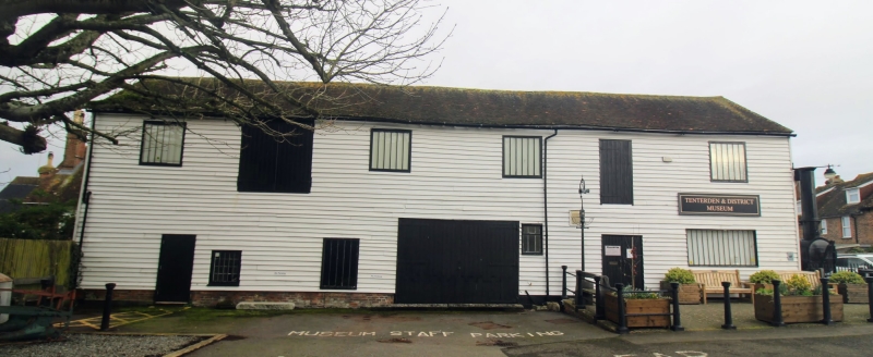
1715 STATION ROAD
Derelict industrial building
to rear of No 82 High Street
TQ 8833 1/191
II
2.
Late C18 to early C19. 2 storeys weatherboarded. Hipped tiled roof.
3 casements.
Listing NGR: TQ8818533304
External links are from the relevant listing authority and, where applicable, Wikidata. Wikidata IDs may be related buildings as well as this specific building. If you want to add or update a link, you will need to do so by editing the Wikidata entry.


Other nearby listed buildings
