Approximate Location Map
Large Map »
Latitude: 51.1103 / 51°6'37"N
Longitude: 0.6465 / 0°38'47"E
OS Eastings: 585347
OS Northings: 137888
OS Grid: TQ853378
Mapcode National: GBR QVN.88D
Mapcode Global: VHJN8.5C35
Plus Code: 9F324J6W+4H
Entry Name: Dashmonden
Listing Date: 9 August 1979
Grade: II
Source: Historic England
Source ID: 1362922
English Heritage Legacy ID: 180215
ID on this website: 101362922
Location: Biddenden, Ashford, Kent, TN27
County: Kent
District: Ashford
Civil Parish: Biddenden
Traditional County: Kent
Lieutenancy Area (Ceremonial County): Kent
Tagged with: Building
BIDDENDEN TENTERDEN ROAD
1.
5272
Dashmonden
TQ 83 NE 4/134
II
2.
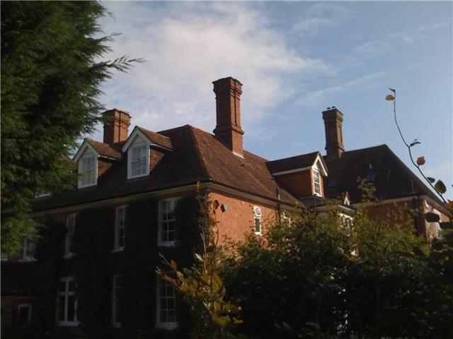
The north front is C18. Two 2 storeys and attics. Red brick and grey headers.
Hipped tiled roof with 2 large gabled dormers. Wooden eaves cornice. Five
sashes with most glazing bars intact. Large C19 additions to the south.
Listing NGR: TQ8523437720
External links are from the relevant listing authority and, where applicable, Wikidata. Wikidata IDs may be related buildings as well as this specific building. If you want to add or update a link, you will need to do so by editing the Wikidata entry.


Other nearby listed buildings
