Approximate Location Map
Large Map »
Latitude: 51.0534 / 51°3'12"N
Longitude: 0.6245 / 0°37'28"E
OS Eastings: 584036
OS Northings: 131502
OS Grid: TQ840315
Mapcode National: GBR QW6.W5S
Mapcode Global: FRA D66B.F41
Plus Code: 9F323J3F+8Q
Entry Name: Saxbys
Listing Date: 4 June 1952
Grade: II
Source: Historic England
Source ID: 1116250
English Heritage Legacy ID: 180307
ID on this website: 101116250
Location: Rolvenden, Ashford, Kent, TN17
County: Kent
District: Ashford
Civil Parish: Rolvenden
Traditional County: Kent
Lieutenancy Area (Ceremonial County): Kent
Tagged with: Building
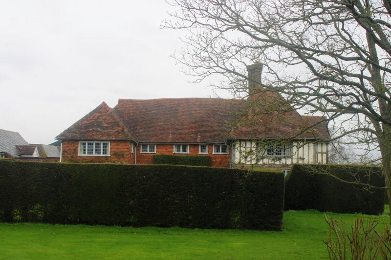
ROLVENDEN BENENDEN ROAD
1.
5272
(north side)
Saxbys
TQ 8431 18/261 4.6.52.
II
2.
T-shaped restored C16 or earlier timber framed building with plaster infilling,
the ground floor rebuilt in red brick. Two storeys and attics. Tiled roof
with one dormer. Four casement windows. Modern 2-storeyed gabled projection
in the centre and small modern addition at the west end. The interior has
a panel carved with the date 1677 and the initials R G (the Gybbon family
of Hole Park).
Listing NGR: TQ8403631502
External links are from the relevant listing authority and, where applicable, Wikidata. Wikidata IDs may be related buildings as well as this specific building. If you want to add or update a link, you will need to do so by editing the Wikidata entry.


Other nearby listed buildings
