Approximate Location Map
Large Map »
Latitude: 51.0513 / 51°3'4"N
Longitude: 0.6304 / 0°37'49"E
OS Eastings: 584458
OS Northings: 131283
OS Grid: TQ844312
Mapcode National: GBR QWD.45L
Mapcode Global: FRA D66B.PDM
Plus Code: 9F323J2J+G5
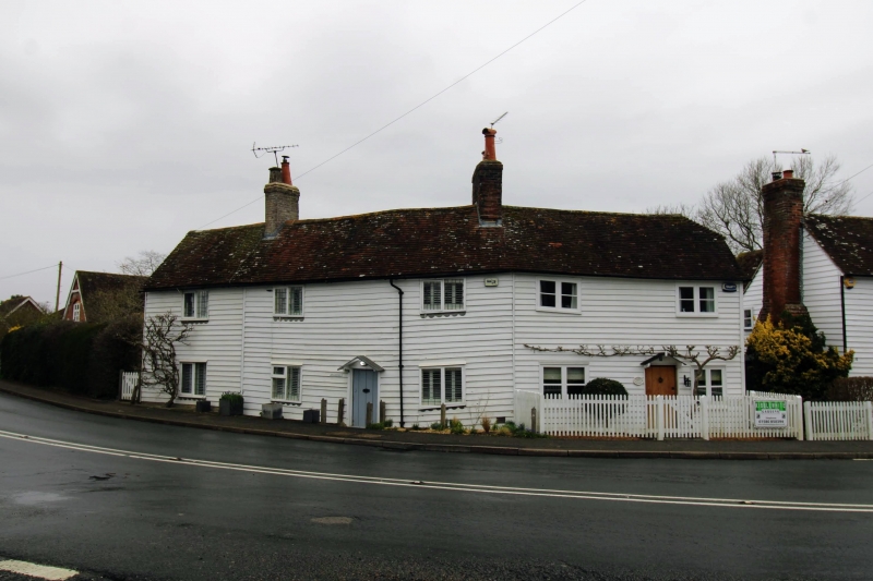
Entry Name: 2 and 4, High Street
Listing Date: 9 August 1979
Grade: II
Source: Historic England
Source ID: 1070914
English Heritage Legacy ID: 180326
ID on this website: 101070914
Location: Rolvenden, Ashford, Kent, TN17
County: Kent
District: Ashford
Civil Parish: Rolvenden
Built-Up Area: Rolvenden
Traditional County: Kent
Lieutenancy Area (Ceremonial County): Kent
Tagged with: Building
This list entry was subject to a Minor Amendment on 12/06/2012
TQ 8431 18/286
5272
ROLVENDEN
HIGH STREET
(north-east side)
Nos 2 and 4
(Formerly listed under Nos 2 and 4, Hastings Road)
GV
II
Pair of C18 cottages. Two storeys 2 windows each faced with weatherboarding.
Casement windows with small square leaded panes. No 2 has a doorcase with
pediment-shaped hood.
Listing NGR: TQ8447731264
External links are from the relevant listing authority and, where applicable, Wikidata. Wikidata IDs may be related buildings as well as this specific building. If you want to add or update a link, you will need to do so by editing the Wikidata entry.


Other nearby listed buildings
