Approximate Location Map
Large Map »
Latitude: 51.0413 / 51°2'28"N
Longitude: 0.643 / 0°38'34"E
OS Eastings: 585381
OS Northings: 130209
OS Grid: TQ853302
Mapcode National: GBR QWF.MDD
Mapcode Global: FRA D67C.GB9
Plus Code: 9F322JRV+G6
Entry Name: 36 and 38, Maytham Road
Listing Date: 9 August 1979
Grade: II
Source: Historic England
Source ID: 1087081
English Heritage Legacy ID: 180378
ID on this website: 101087081
Location: Rolvenden Layne, Ashford, Kent, TN17
County: Kent
District: Ashford
Civil Parish: Rolvenden
Built-Up Area: Rolvenden Layne
Traditional County: Kent
Lieutenancy Area (Ceremonial County): Kent
Tagged with: Building
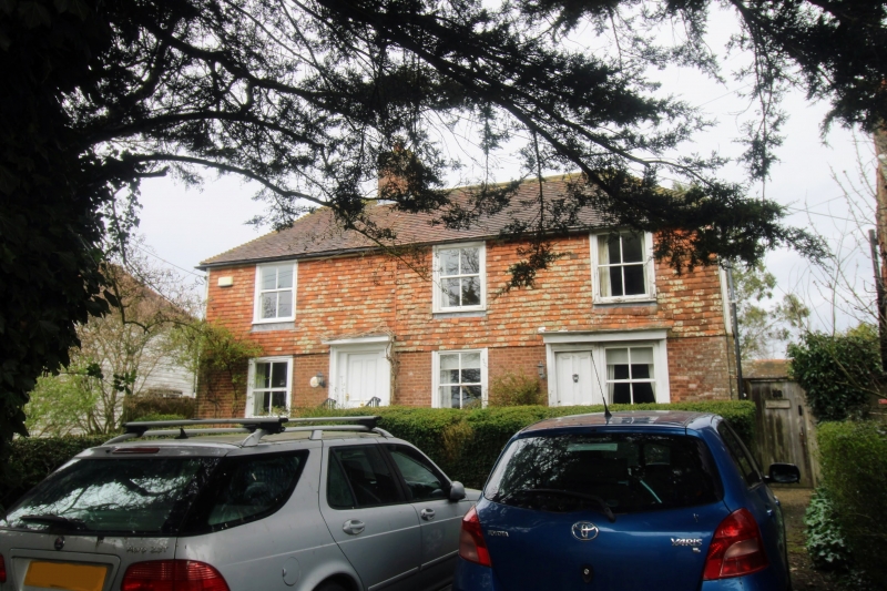
ROLVENDEN MAYTHAM ROAD
1.
5272 (north-west side)
Rolvenden Layne
Nos 36 and 38
TQ 8530 20/334
II GV
2.
Early C19. Two storeys. Ground floor red brick. First floor tile hung.
Slate roof. Three sashes with some glazing bars intact. Simple weather hoods.
Listing NGR: TQ8538130209
External links are from the relevant listing authority and, where applicable, Wikidata. Wikidata IDs may be related buildings as well as this specific building. If you want to add or update a link, you will need to do so by editing the Wikidata entry.


Other nearby listed buildings
