Approximate Location Map
Large Map »
Latitude: 51.2117 / 51°12'42"N
Longitude: 0.7511 / 0°45'3"E
OS Eastings: 592248
OS Northings: 149432
OS Grid: TQ922494
Mapcode National: GBR RVR.YH8
Mapcode Global: VHKK5.YSYZ
Plus Code: 9F326Q62+MC
Entry Name: Church of the Holy Trinity
Listing Date: 10 October 1980
Grade: II
Source: Historic England
Source ID: 1070772
English Heritage Legacy ID: 180705
ID on this website: 101070772
Location: Holy Trinity Church, Charing Heath, Ashford, Kent, TN27
County: Kent
District: Ashford
Civil Parish: Charing
Built-Up Area: Charing Heath
Traditional County: Kent
Lieutenancy Area (Ceremonial County): Kent
Tagged with: Church building
1.
5272 CHARING CHURCH HILL
Charing Heath
Church of the Holy
Trinity
TQ 94 NW 10/118
II
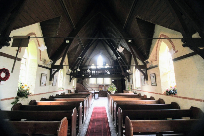
2.
1874. Built of stone rubble. Nave. North porch. Apsidal ended with bellcote.
Lancet windows. The interior has a steeply-pitched wooden roof with sexfoil
oculi. Wooden choir loft to west.
Listing NGR: TQ9250249337
External links are from the relevant listing authority and, where applicable, Wikidata. Wikidata IDs may be related buildings as well as this specific building. If you want to add or update a link, you will need to do so by editing the Wikidata entry.


Other nearby listed buildings
