Approximate Location Map
Large Map »
Latitude: 51.2108 / 51°12'38"N
Longitude: 0.7946 / 0°47'40"E
OS Eastings: 595289
OS Northings: 149443
OS Grid: TQ952494
Mapcode National: GBR RW0.3NZ
Mapcode Global: VHKK6.QTFP
Plus Code: 9F326Q6V+8R
Entry Name: 45, High Street
Listing Date: 25 July 1978
Grade: II
Source: Historic England
Source ID: 1070744
English Heritage Legacy ID: 180734
ID on this website: 101070744
Location: Charing, Ashford, Kent, TN27
County: Kent
District: Ashford
Civil Parish: Charing
Built-Up Area: Ashford (Ashford)
Traditional County: Kent
Lieutenancy Area (Ceremonial County): Kent
Tagged with: Building
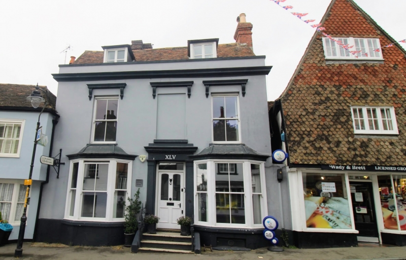
1.
5272 CHARING HIGH STREET
(west side)
No 45
TQ 9549 22/88 25.7.78
II GV
2.
C18 or earlier refronted in cement in the mid C19. Two parallel ranges. Two
storeys and attics. Tiled roof with 2 dormers and large brick stack. Coping.
Moulded cornice. Two sashes and one blank to first floor, with verticals
only and cornice and brackets above. Two 3-light canted bays to ground floor
with canopies over and central doorcase with pilasters and dentil cornice.
Listing NGR: TQ9528749442
External links are from the relevant listing authority and, where applicable, Wikidata. Wikidata IDs may be related buildings as well as this specific building. If you want to add or update a link, you will need to do so by editing the Wikidata entry.


Other nearby listed buildings
