Approximate Location Map
Large Map »
Latitude: 51.2115 / 51°12'41"N
Longitude: 0.7956 / 0°47'44"E
OS Eastings: 595361
OS Northings: 149520
OS Grid: TQ953495
Mapcode National: GBR RVT.XNJ
Mapcode Global: VHKK6.QTZ5
Plus Code: 9F326Q6W+H7
Entry Name: Wakeley Villas
Listing Date: 14 February 1967
Grade: II
Source: Historic England
Source ID: 1299508
English Heritage Legacy ID: 180742
ID on this website: 101299508
Location: Charing, Ashford, Kent, TN27
County: Kent
District: Ashford
Civil Parish: Charing
Built-Up Area: Charing
Traditional County: Kent
Lieutenancy Area (Ceremonial County): Kent
Tagged with: Architectural structure
1.
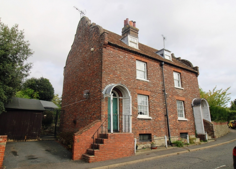
5272 CHARING HIGH STREET
(west side)
Wakeley Villas
(Nos 1 and 2)
TQ 9549 22/28 14.2.67
II
2.
Pair of C18 cottages. Two storeys and basement red brick. Tiled roof with
shaped Dutch gable ends. Modillion eaves cornice. Two sashes with glazing
bars intact. Round-headed doorways with semi-circular fanlights. Later wooden
round headed porches added.
Listing NGR: TQ9522049297
External links are from the relevant listing authority and, where applicable, Wikidata. Wikidata IDs may be related buildings as well as this specific building. If you want to add or update a link, you will need to do so by editing the Wikidata entry.


Other nearby listed buildings
