Approximate Location Map
Large Map »
Latitude: 51.2095 / 51°12'34"N
Longitude: 0.7938 / 0°47'37"E
OS Eastings: 595241
OS Northings: 149295
OS Grid: TQ952492
Mapcode National: GBR RW0.3HY
Mapcode Global: VHKK6.QV0P
Plus Code: 9F326Q5V+QG
Entry Name: 6 and 8, High Street
Listing Date: 10 October 1980
Grade: II
Source: Historic England
Source ID: 1070749
English Heritage Legacy ID: 180746
ID on this website: 101070749
Location: Charing, Ashford, Kent, TN27
County: Kent
District: Ashford
Civil Parish: Charing
Built-Up Area: Charing
Traditional County: Kent
Lieutenancy Area (Ceremonial County): Kent
Tagged with: Building
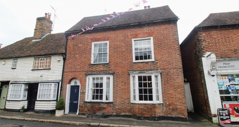
1.
5272 CHARING HIGH STREET
(east side)
Nos 6 and 8
TQ 9549 22/26
II GV
2.
C18. Two storeys and attic gable end. Red brick. Tiled roof with modillion
eaves cornice. One sash each with glazing bars missing to the first floor
of No 8. Two 3-light canted bays to ground floor. No 8 has a round-headed
doorcase with semi-circular fanlight and 6 panelled door. No 6 has a doorcase
with flat hood and brackets in its side elevation.
Listing NGR: TQ9524049292
External links are from the relevant listing authority and, where applicable, Wikidata. Wikidata IDs may be related buildings as well as this specific building. If you want to add or update a link, you will need to do so by editing the Wikidata entry.


Other nearby listed buildings
