Approximate Location Map
Large Map »
Latitude: 51.211 / 51°12'39"N
Longitude: 0.7945 / 0°47'40"E
OS Eastings: 595281
OS Northings: 149463
OS Grid: TQ952494
Mapcode National: GBR RW0.3NX
Mapcode Global: VHKK6.QTCJ
Plus Code: 9F326Q6V+9Q
Entry Name: Ledbury House
Listing Date: 25 July 1978
Grade: II
Source: Historic England
Source ID: 1071542
English Heritage Legacy ID: 180789
ID on this website: 101071542
Location: Charing, Ashford, Kent, TN27
County: Kent
District: Ashford
Civil Parish: Charing
Built-Up Area: Charing
Traditional County: Kent
Lieutenancy Area (Ceremonial County): Kent
Tagged with: House
1.
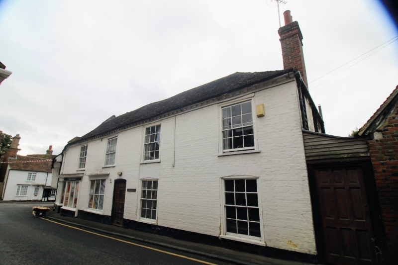
5272 CHARING SCHOOL ROAD
Ledbury House
TQ 9549 22/53 25.7.78
II
2.
C18. Two storeys painted brick. Hipped tiled roof with modillion eaves cornice.
Five sashes with glazing bars intact. Modern shop-front at the south-east
end.
Listing NGR: TQ9528449458
External links are from the relevant listing authority and, where applicable, Wikidata. Wikidata IDs may be related buildings as well as this specific building. If you want to add or update a link, you will need to do so by editing the Wikidata entry.


Other nearby listed buildings
