Approximate Location Map
Large Map »
Latitude: 51.2115 / 51°12'41"N
Longitude: 0.7945 / 0°47'40"E
OS Eastings: 595278
OS Northings: 149521
OS Grid: TQ952495
Mapcode National: GBR RVT.XB5
Mapcode Global: VHKK6.QTC4
Plus Code: 9F326Q6V+HQ
Entry Name: Gazebo to Rear of Ludwell House
Listing Date: 10 October 1980
Grade: II
Source: Historic England
Source ID: 1186100
English Heritage Legacy ID: 180792
ID on this website: 101186100
Location: Charing, Ashford, Kent, TN27
County: Kent
District: Ashford
Civil Parish: Charing
Built-Up Area: Charing
Traditional County: Kent
Lieutenancy Area (Ceremonial County): Kent
Tagged with: Gazebo
This list entry was subject to a Minor Amendment on 12/06/2012
TQ 9549 22/54A
5272
CHARING
SCHOOL ROAD
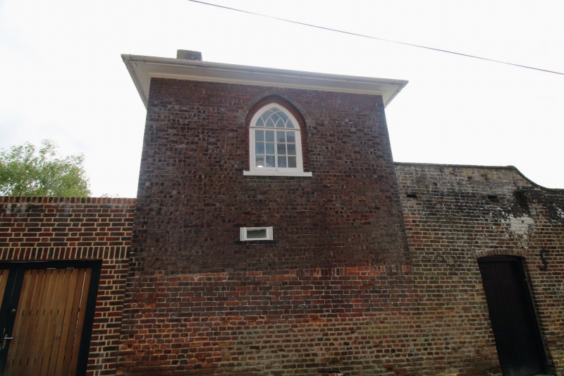
Gazebo to rear of Ludwell House
(Formerly listed as Gazebo to rear of Romney House)
II
Early C19. Square building of 2 storeys with one window in each front. Red
brick with grey headers. Hipped slate roof with eaves cornice. Pointed Gothick
windows with glazing bars intact.
Listing NGR: TQ9527649519
External links are from the relevant listing authority and, where applicable, Wikidata. Wikidata IDs may be related buildings as well as this specific building. If you want to add or update a link, you will need to do so by editing the Wikidata entry.


Other nearby listed buildings
