Approximate Location Map
Large Map »
Latitude: 51.195 / 51°11'41"N
Longitude: 0.7298 / 0°43'47"E
OS Eastings: 590828
OS Northings: 147515
OS Grid: TQ908475
Mapcode National: GBR QTS.58V
Mapcode Global: VHKKC.L7N8
Plus Code: 9F325PVH+XW
Entry Name: Church House
Listing Date: 10 October 1980
Grade: II
Source: Historic England
Source ID: 1319982
English Heritage Legacy ID: 180871
ID on this website: 101319982
Location: Egerton, Ashford, Kent, TN27
County: Kent
District: Ashford
Civil Parish: Egerton
Traditional County: Kent
Lieutenancy Area (Ceremonial County): Kent
Tagged with: House
1.
5272 EGERTON THE STREET
(south-east side)
Church House
TQ 94 NW 10/3
II GV
2.
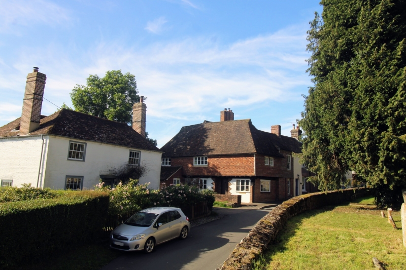
A timber-framed building, probably a late mediaeval hall-house, refaced on
the ground floor of the west front with red brick and of the north front with
stucco, above tile-hung, the first floor of the north and west fronts oversailing
on the protruding ends of the floor joists and brackets. Moulded corner post
to dragon beam. Hipped tiled roof with smoke louvres. Casement windows,
one window facing west and 2 windows facing north.
Listing NGR: TQ9082947512
External links are from the relevant listing authority and, where applicable, Wikidata. Wikidata IDs may be related buildings as well as this specific building. If you want to add or update a link, you will need to do so by editing the Wikidata entry.


Other nearby listed buildings
