Approximate Location Map
Large Map »
Latitude: 51.1748 / 51°10'29"N
Longitude: 0.7525 / 0°45'9"E
OS Eastings: 592501
OS Northings: 145335
OS Grid: TQ925453
Mapcode National: GBR RWB.C1K
Mapcode Global: VHKKD.0Q5Q
Plus Code: 9F325QF3+W2
Entry Name: Forge Hill House
Listing Date: 10 October 1980
Last Amended: 25 February 1981
Grade: II
Source: Historic England
Source ID: 1071417
English Heritage Legacy ID: 181090
ID on this website: 101071417
Location: Pluckley, Ashford, Kent, TN27
County: Kent
District: Ashford
Civil Parish: Pluckley
Built-Up Area: Pluckley Thorne
Traditional County: Kent
Lieutenancy Area (Ceremonial County): Kent
Tagged with: House
This list entry was subject to a Minor Amendment on 15/01/2013
TQ 9245 27/10
5272
PLUCKLEY
FORGE HILL
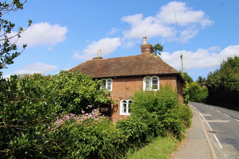
Forge Hill House
(Formerly listed as Hillside)
II
C18 L-shaped building. Two storeys. South wing red brick, north wing stone
rubble. Hipped tiled roof. Two Dering windows. Doorcase with flat hood over
on scroll brackets.
Listing NGR: TQ9250145335
External links are from the relevant listing authority and, where applicable, Wikidata. Wikidata IDs may be related buildings as well as this specific building. If you want to add or update a link, you will need to do so by editing the Wikidata entry.


Other nearby listed buildings
