Approximate Location Map
Large Map »
Latitude: 51.168 / 51°10'4"N
Longitude: 0.7483 / 0°44'53"E
OS Eastings: 592236
OS Northings: 144560
OS Grid: TQ922445
Mapcode National: GBR RWB.Q0Q
Mapcode Global: VHKKC.XXG0
Plus Code: 9F325P9X+58
Entry Name: Snagsmount
Listing Date: 10 October 1980
Grade: II
Source: Historic England
Source ID: 1186775
English Heritage Legacy ID: 181094
ID on this website: 101186775
Location: Fir Toll, Ashford, Kent, TN27
County: Kent
District: Ashford
Civil Parish: Pluckley
Built-Up Area: Pluckley Thorne
Traditional County: Kent
Lieutenancy Area (Ceremonial County): Kent
Tagged with: Building
1.
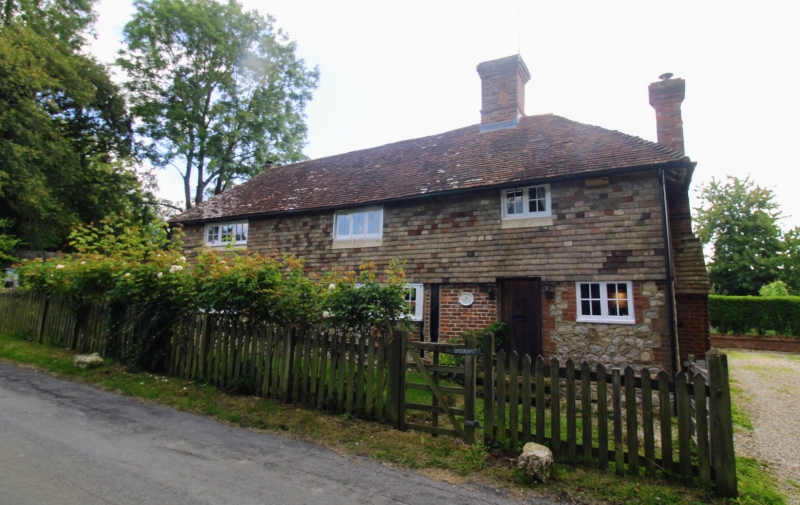
5272 PLUCKLEY LAMSDEN ROAD
Snagsmount
TQ 94 SW 14/57
II
2.
C17 or earlier timber-framed building with early C19 facade. Two storeys.
Ground floor Kentish ragstone, first floor tile-hung. Hipped tiled roof. Two
casement windows. Some timber-framing visible on the ground floor.
Listing NGR: TQ9223644560
External links are from the relevant listing authority and, where applicable, Wikidata. Wikidata IDs may be related buildings as well as this specific building. If you want to add or update a link, you will need to do so by editing the Wikidata entry.


Other nearby listed buildings
