Approximate Location Map
Large Map »
Latitude: 51.1461 / 51°8'45"N
Longitude: 0.659 / 0°39'32"E
OS Eastings: 586084
OS Northings: 141897
OS Grid: TQ860418
Mapcode National: GBR QV8.5FL
Mapcode Global: VHJN2.CGR8
Plus Code: 9F324MW5+CJ
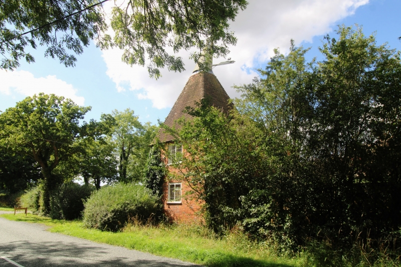
Entry Name: Oast Cottage
Listing Date: 10 October 1980
Grade: II
Source: Historic England
Source ID: 1362676
English Heritage Legacy ID: 181169
ID on this website: 101362676
Location: Monk's Hill, Ashford, Kent, TN27
County: Kent
District: Ashford
Civil Parish: Smarden
Traditional County: Kent
Lieutenancy Area (Ceremonial County): Kent
Tagged with: Cottage
1.
5272 SMARDEN BELL LANE
Oast Cottage
TQ 8641 30/91
II
2.
Formerly an oasthouse to Barnden. C18. Two storey brick outbuilding with
a square brick oast attached, having pyramidal tiled roof with cowl and fantail.
Listing NGR: TQ8608441897
External links are from the relevant listing authority and, where applicable, Wikidata. Wikidata IDs may be related buildings as well as this specific building. If you want to add or update a link, you will need to do so by editing the Wikidata entry.


Other nearby listed buildings
