Approximate Location Map
Large Map »
Latitude: 51.1566 / 51°9'23"N
Longitude: 0.7208 / 0°43'14"E
OS Eastings: 590358
OS Northings: 143224
OS Grid: TQ903432
Mapcode National: GBR QV5.H18
Mapcode Global: VHKKK.F6X6
Plus Code: 9F325P4C+J8
Entry Name: Maltman's Hill House
Listing Date: 14 February 1967
Grade: II
Source: Historic England
Source ID: 1362704
English Heritage Legacy ID: 181225
ID on this website: 101362704
Location: Maltman's Hill, Ashford, Kent, TN27
County: Kent
District: Ashford
Civil Parish: Smarden
Traditional County: Kent
Lieutenancy Area (Ceremonial County): Kent
Tagged with: House
1.
5272 SMARDEN PLUCKLEY ROAD
Maltman's Hill
Maltman's Hill House
TQ 94 SW 4/87 14.2.67.
II
2.
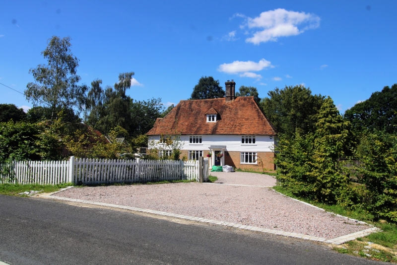
A late mediaeval timber-framed building. Red brick or grey headers to ground
floor, weatherboarded to first floor. Steeply-pitched hipped tiled roof, with
one hipped dormer to attic storey. Three casement windows. Small porch.
Listing NGR: TQ9035843224
External links are from the relevant listing authority and, where applicable, Wikidata. Wikidata IDs may be related buildings as well as this specific building. If you want to add or update a link, you will need to do so by editing the Wikidata entry.


Other nearby listed buildings
