Approximate Location Map
Large Map »
Latitude: 51.1494 / 51°8'58"N
Longitude: 0.6882 / 0°41'17"E
OS Eastings: 588107
OS Northings: 142345
OS Grid: TQ881423
Mapcode National: GBR QV4.SZ6
Mapcode Global: VHJN2.WC5P
Plus Code: 9F324MXQ+Q7
Entry Name: Village Pump
Listing Date: 10 October 1980
Grade: II
Source: Historic England
Source ID: 1359668
English Heritage Legacy ID: 181268
ID on this website: 101359668
Location: Smarden, Ashford, Kent, TN27
County: Kent
District: Ashford
Civil Parish: Smarden
Built-Up Area: Smarden
Traditional County: Kent
Lieutenancy Area (Ceremonial County): Kent
Tagged with: Well
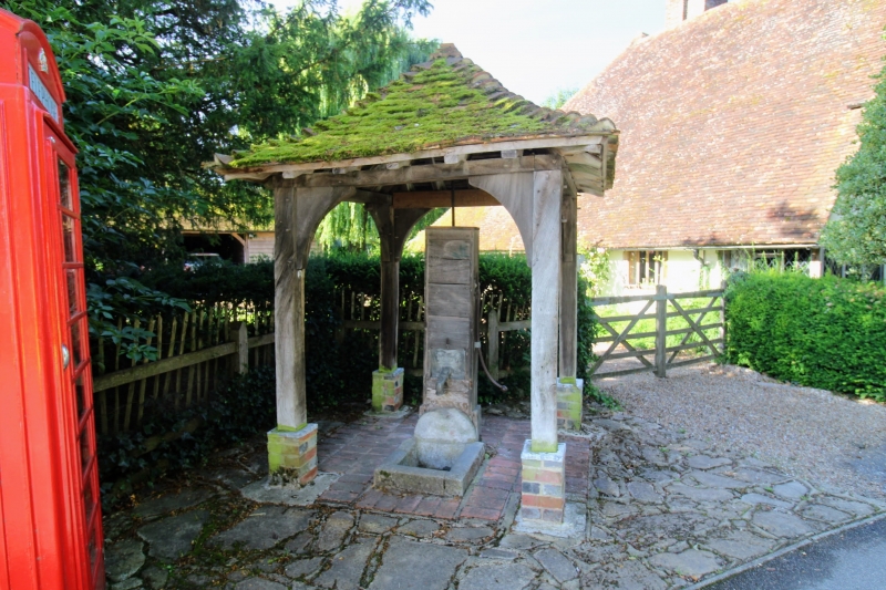
1.
5272 SMARDEN THE STREET
(south side)
Village pump
TQ 8842 29/103
II
2.
This consists of a lead waterspout, dated 1897, with an iron pump handle and
a stone receptacle below. Beneath a modern wooden shelter.
Listing NGR: TQ8810742344
External links are from the relevant listing authority and, where applicable, Wikidata. Wikidata IDs may be related buildings as well as this specific building. If you want to add or update a link, you will need to do so by editing the Wikidata entry.


Other nearby listed buildings
