Approximate Location Map
Large Map »
Latitude: 51.244 / 51°14'38"N
Longitude: 0.9626 / 0°57'45"E
OS Eastings: 606873
OS Northings: 153599
OS Grid: TR068535
Mapcode National: GBR SWZ.XX1
Mapcode Global: VHKK3.MZRP
Plus Code: 9F326XV7+J2
Entry Name: Churchyard Wall from the Olde Cottage 20 Yards to Bakery House
Listing Date: 13 August 1984
Grade: II
Source: Historic England
Source ID: 1362745
English Heritage Legacy ID: 181437
ID on this website: 101362745
Location: Chilham, Ashford, Kent, CT4
County: Kent
District: Ashford
Civil Parish: Chilham
Built-Up Area: Chilham
Traditional County: Kent
Lieutenancy Area (Ceremonial County): Kent
Tagged with: Churchyard wall
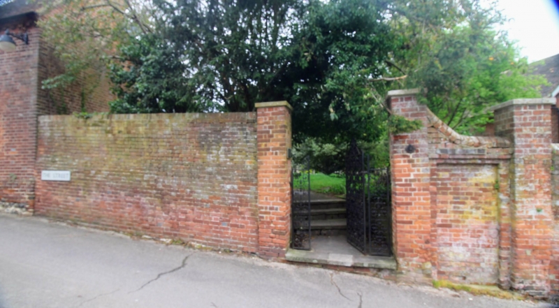
TR 0653-0753 CHILHAM HIGH STREET
(north side)
7/16 Churchyard Wall
from the Olde Cottage
20 yards to Bakery
House
GV II
Wall. C18. Red brick. 6 feet high, 20 yards in length. 1960's
wrought iron gate, with beyond a blocked opening with gate pier
and at east end wooden door in opening with projecting gate
piers. Included for group value only.
Listing NGR: TR0687053603
External links are from the relevant listing authority and, where applicable, Wikidata. Wikidata IDs may be related buildings as well as this specific building. If you want to add or update a link, you will need to do so by editing the Wikidata entry.


Other nearby listed buildings
