Approximate Location Map
Large Map »
Latitude: 51.0904 / 51°5'25"N
Longitude: 0.9207 / 0°55'14"E
OS Eastings: 604629
OS Northings: 136399
OS Grid: TR046363
Mapcode National: GBR SYV.KLK
Mapcode Global: FRA D6T7.NHJ
Plus Code: 9F323WRC+57
Entry Name: The Bourne Tap
Listing Date: 10 August 1988
Grade: II
Source: Historic England
Source ID: 1071186
English Heritage Legacy ID: 181643
ID on this website: 101071186
Location: Aldington Frith, Ashford, Kent, TN25
County: Kent
District: Ashford
Civil Parish: Bilsington
Traditional County: Kent
Lieutenancy Area (Ceremonial County): Kent
Tagged with: Building
TR 03 NW BILSINGTON BOURNE ROAD
(west side)
3/58 The Bourne Tap
II
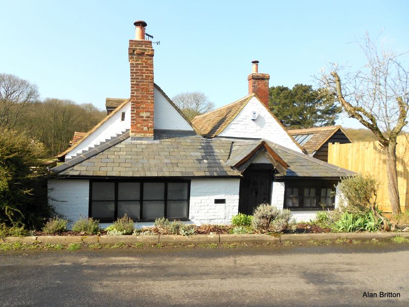
Former beerhouse, now house. Circa 1800 but with early-C20 extensions to the north-west, southwest and north-east and 1970s extension to the north-west none of special interest.
MATERIALS: The north wall of the north range retains original weatherboarding, the gable ends are of painted brick, the south range is rendered with gabled tiled roofs and external brick chimneystacks.
PLAN: The original part is of two parallel ranges, each of one storey and containing one large room.
EXTERIOR: The original main entrance is on the north side, now approached through an early-C20 extension. Part of the original weatherboarded front wall remains, together with a brick external chimneystack and wide right side doorcase with wooden surround and ledged plank door with Lhinges. The eastern part of the original north wall was removed when the early-C20 extension was added. The side gable ends are of painted brick and an external brick chimneystack is attached to the east side of the south range. The south wall of the original building is rendered with a central early-C20 gable, wooden early-C20 door with horizontal glazing and two three-light 1930s metal casements.
INTERIOR: The north range of the original cottage has a C19 Tudor-arched fireplace over an earlier brick surround. The ceiling has the lower part of thin rafters exposed with thin horizontal beams connecting each pair. The original partition wall of lath and plaster between the north and south ranges survives. The south range is accessed internally through a ledged plank door and has a similar ceiling. To the east is a cambered brick firelace with some late-C18 or early-C19 bricks and a wooden beam above across the full width of the room. The roof was not inspected but was reported to be of C20 softwood.
HISTORY: The Bourne Tap was a cottage belonging to George Ransley, the last of the Kentish smuggling gang leaders, leader of the Aldington gang of smugglers. The Aldington Gang worked the coast between Dover and Rye during the 1820s on an industrial scale and could muster 300 men. Although Ransley's official occupation was farming, he sold smuggled liquor at his cottage which was run as an unlicensed beerhouse, notorious for drunkenness and unbridled sexual licence. It was also the focal point of his distribution system for contraband goods, selling up to 100 tubs of spirits a week from here.
On 18th July 1826 the smugglers killed a quartermaster in a boat off Dover beach and a large reward was offered. As a result, informers tipped off the authorities and a group of blockade men and two Bow Street Runners marched on the Bourne Tap, capturing George Ransley and seven others. Nineteen smugglers were tried at Maidsone Assizes in January 1827 and found guilty of capital offences but their counsel managed to get the sentences commuted to transportation to Tasmania. The building is shown on the First Edition OS map of 1872 and was sketched by Charles Igglesden on the title page to Aldington in his early-C20 volumes "Saunters through Kent with pen and pencil".
REASON FOR DESIGNATION: The Bourne Tap is designated for the following principal reasons:
* Although this building was much extended in the C20, at its core is the late C18 or early C19
cottage owned by the notorious smuggler George Ransley, the head of the Ransley gang, and the site
of his arrest in 1827;
* This building has historic interest on a local and national level as a notable building in the history
of smuggling, one of the principal industries in coastal regions in the C18 and early-C19;
* The C20 extensions are not of special interest.
SOURCES:
Charles Igglesden "Saunters through Kent with pen and pencil". Sketch of the building as it appeared in the early C20 on title page to Aldington parish.
Mary Waugh "Smuggling in Kent and Sussex 1700-1800" 1985. P82.
Bibliography
33770: Smuggling in Kent and Sussex 1700-1890 (Mary Waugh), 1985, Page(s) 82
External links are from the relevant listing authority and, where applicable, Wikidata. Wikidata IDs may be related buildings as well as this specific building. If you want to add or update a link, you will need to do so by editing the Wikidata entry.


Other nearby listed buildings
