Approximate Location Map
Large Map »
Latitude: 54.12 / 54°7'12"N
Longitude: -2.7759 / 2°46'33"W
OS Eastings: 349383
OS Northings: 469630
OS Grid: SD493696
Mapcode National: GBR 9N1S.TV
Mapcode Global: WH83V.BPDW
Plus Code: 9C6V46CF+2J
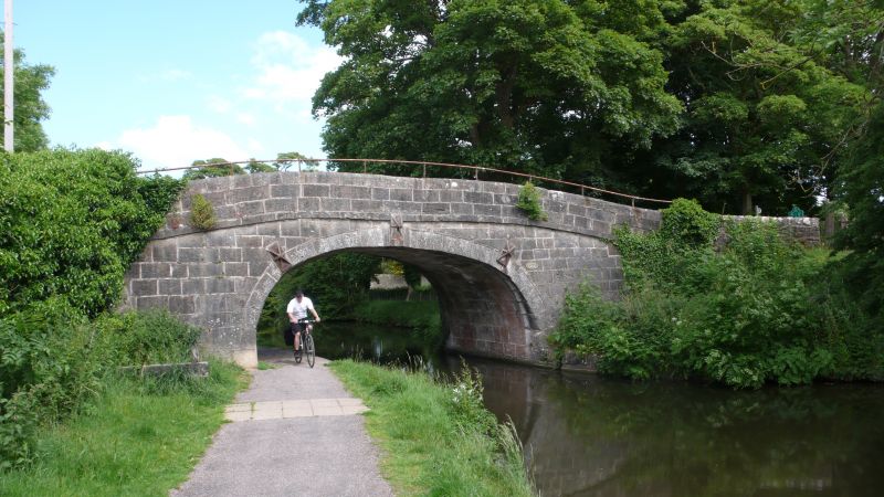
Entry Name: Lancaster Canal Thwaite End Bridge (Number 127)
Listing Date: 7 November 1983
Grade: II
Source: Historic England
Source ID: 1071922
English Heritage Legacy ID: 181828
ID on this website: 101071922
Location: Crag Bank, Lancaster, Lancashire, LA5
County: Lancashire
District: Lancaster
Civil Parish: Carnforth
Built-Up Area: Carnforth
Traditional County: Lancashire
Lieutenancy Area (Ceremonial County): Lancashire
Church of England Parish: Carnforth Christ Church
Church of England Diocese: Blackburn
SD 46 NE CARNFORTH MAIN A6 ROAD (Off)
6/75 Thwaite End Bridge, (No 127)
II
Bridge over Lancaster Canal, opened in 1797. Large gritstone blocks.
Semi-elliptical arch with raised keystone. String course below round-topped
parapet.
Listing NGR: SD4938369630
External links are from the relevant listing authority and, where applicable, Wikidata. Wikidata IDs may be related buildings as well as this specific building. If you want to add or update a link, you will need to do so by editing the Wikidata entry.


Other nearby listed buildings
