Approximate Location Map
Large Map »
Latitude: 54.183 / 54°10'58"N
Longitude: -2.5601 / 2°33'36"W
OS Eastings: 363544
OS Northings: 476502
OS Grid: SD635765
Mapcode National: GBR BNK2.K8
Mapcode Global: WH94W.N432
Plus Code: 9C6V5CMQ+5X
Entry Name: Boundary Stone
Listing Date: 4 December 1985
Grade: II
Source: Historic England
Source ID: 1071708
English Heritage Legacy ID: 182342
ID on this website: 101071708
Location: Overtown, Lancaster, Lancashire, LA6
County: Lancashire
District: Lancaster
Civil Parish: Leck
Traditional County: Lancashire
Lieutenancy Area (Ceremonial County): Lancashire
Church of England Parish: Tunstall St John the Baptist and Melling St Wilfred and Leck St Peter
Church of England Diocese: Blackburn
Tagged with: Boundary marker
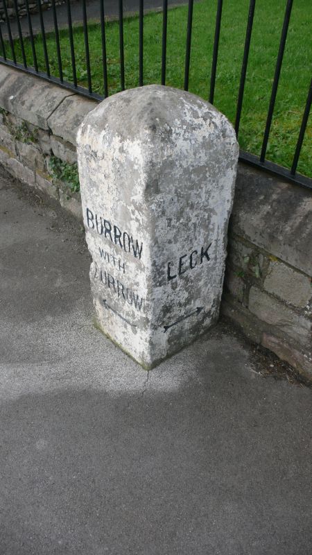
BURROW-WITH-BURROW A65
SD 67 NW
2/48 Boundary stone
GV II
Boundary stone, mid C19th, sandstone, Square plan, with rounded top. Front
face inscribed: 'BURROW WITH BURROW', with arrow. Left-hand and right-hand
faces each inscribed: 'LECK', with arrows. Part of this boundary stone is
in Leck C.P. (q.v.)
Listing NGR: SD6354476502
External links are from the relevant listing authority and, where applicable, Wikidata. Wikidata IDs may be related buildings as well as this specific building. If you want to add or update a link, you will need to do so by editing the Wikidata entry.


Other nearby listed buildings
