Approximate Location Map
Large Map »
Latitude: 53.8839 / 53°53'1"N
Longitude: -2.5749 / 2°34'29"W
OS Eastings: 362308
OS Northings: 443228
OS Grid: SD623432
Mapcode National: GBR BRGJ.BH
Mapcode Global: WH967.FM3X
Plus Code: 9C5VVCMG+G2
Entry Name: John Brabin's Old School
Listing Date: 29 December 1952
Last Amended: 22 November 1983
Grade: II
Source: Historic England
Source ID: 1147304
English Heritage Legacy ID: 182979
ID on this website: 101147304
Location: Chipping, Ribble Valley, Lancashire, PR3
County: Lancashire
District: Ribble Valley
Civil Parish: Chipping
Built-Up Area: Chipping
Traditional County: Lancashire
Lieutenancy Area (Ceremonial County): Lancashire
Church of England Parish: Chipping St Bartholomew
Church of England Diocese: Blackburn
Tagged with: House School building
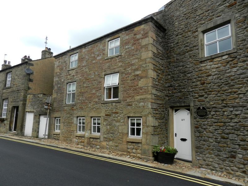
SD 64 SW CHIPPING WINDY STREET
4/92 No. 27 (John Brabin's Old School)
29.12.52 (formerly listed as John Brabin's Old School)
GV II
Former school, 1684, altered. Sandstone rubble with slate roof. 2 storeys,
the upper one now being very tall. 3 bays with central single-storey porch,
continuous drip course which returns along right-hand gable wall, and
cavetto-moulded eaves cornice. On the ground floor are 2 3-light double-
chamfered mullioned windows, the inner chamfer being hollow. The 1st floor
windows have chamfered plain stone surrounds. The porch has an ashlar front,
saddle-backed coping with 3 ball finials, a studded plank door and a badly
worn moulded door surround with shaped lintel and moulded hood. Re-cut on
the lintel are: 'CP RP 1684 JH RM'. Above is a re-cut plaque with moulded
border 'THIS SCHOOL FOUNDED BY JOHN BRABBIN GENTLEMAN DOCE DISCE VEL DISCEDE'.
The left-hand gable has a plain stone door surround with 'GIRLS' on the
lintel. The right-hand gable has a 3-light double-chamfered mullioned
window on the ground floor. At the rear (north-west) are extensions with
an M-roof. The wall facing the river is of 2 storeys and 3 bays, the
windows having plain stone surrounds. The wall facing the road has 4 narrow
doorways with slightly chamfered surrounds, now blocked to form windows.
The right-hand one has '1771' incised on the lintel. Above are lst and
2nd floor windows with plain stone surrounds, and a cavetto cornice.
Listing NGR: SD6230843228
External links are from the relevant listing authority and, where applicable, Wikidata. Wikidata IDs may be related buildings as well as this specific building. If you want to add or update a link, you will need to do so by editing the Wikidata entry.


Other nearby listed buildings
