Approximate Location Map
Large Map »
Latitude: 53.9487 / 53°56'55"N
Longitude: -2.462 / 2°27'43"W
OS Eastings: 369778
OS Northings: 450387
OS Grid: SD697503
Mapcode National: GBR CQ7S.S7
Mapcode Global: WH963.40XP
Plus Code: 9C5VWGXQ+F6
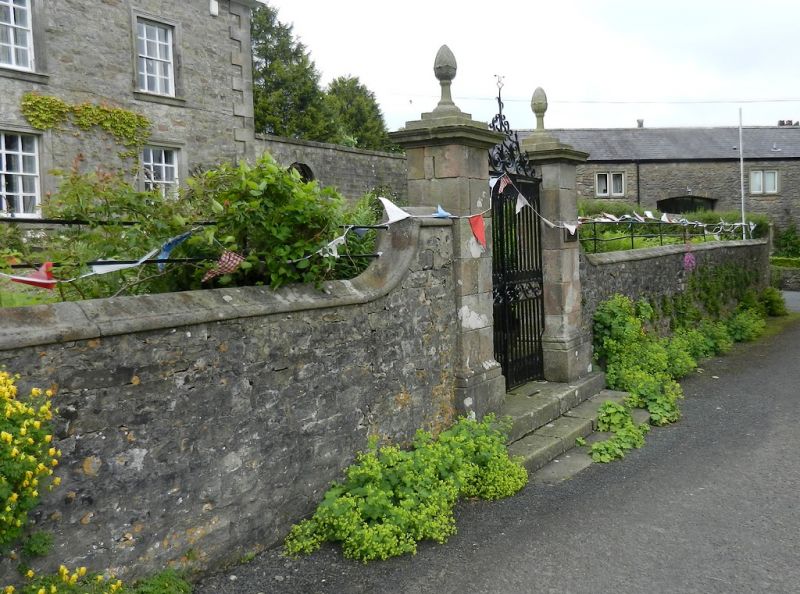
Entry Name: Wall, Gatepiers and Gates South of Newton Hall
Listing Date: 16 November 1954
Last Amended: 16 November 1983
Grade: II
Source: Historic England
Source ID: 1362271
English Heritage Legacy ID: 183098
ID on this website: 101362271
Location: Newton, Ribble Valley, Lancashire, BB7
County: Lancashire
District: Ribble Valley
Civil Parish: Newton
Traditional County: Yorkshire
Lieutenancy Area (Ceremonial County): Lancashire
Church of England Parish: Slaidburn St Andrew
Church of England Diocese: Leeds
SD 6950 NEWTON NEWTON VILLAGE
Wall, gatepiers and gates south
18/47 of Newton Hall
16.11.1954
GV II
Rubble wall, C18th, with moulded sandstone coping, containing 2 sandstone
ashlar gatepiers of square section with moulded cornices, pineapple finials
and wrought iron gates.
Listing NGR: SD6977850387
External links are from the relevant listing authority and, where applicable, Wikidata. Wikidata IDs may be related buildings as well as this specific building. If you want to add or update a link, you will need to do so by editing the Wikidata entry.


Other nearby listed buildings
