Approximate Location Map
Large Map »
Latitude: 53.9669 / 53°58'0"N
Longitude: -2.4417 / 2°26'30"W
OS Eastings: 371120
OS Northings: 452404
OS Grid: SD711524
Mapcode National: GBR CQDK.5Q
Mapcode Global: WH95X.GKJ8
Plus Code: 9C5VXH85+Q8
Entry Name: The Hark to Bounty
Listing Date: 16 November 1954
Last Amended: 16 November 1983
Grade: II
Source: Historic England
Source ID: 1362260
English Heritage Legacy ID: 183153
Also known as: Hark to Bounty Inn
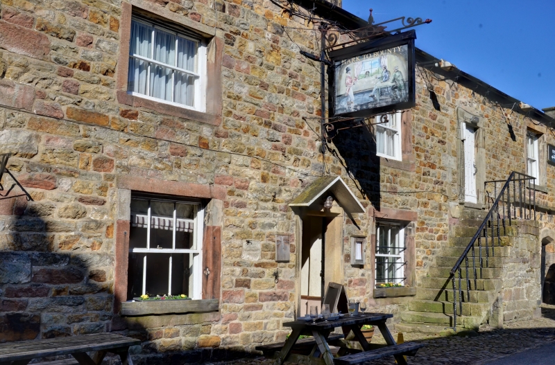
Hark To Bounty Inn
Hark To Bounty Inn, Clitheroe
ID on this website: 101362260
Location: Slaidburn, Ribble Valley, Lancashire, BB7
County: Lancashire
District: Ribble Valley
Civil Parish: Slaidburn
Traditional County: Yorkshire
Lieutenancy Area (Ceremonial County): Lancashire
Church of England Parish: Slaidburn St Andrew
Church of England Diocese: Leeds
Tagged with: Pub
SD 7052-7152 SIAIDBURN TOWN END (NORTH SIDE)
17/102 The Hark to Bounty
16.11.1954 (Formerly listed as Hark to Bounty Inn)
GV II
Public house, probably early C17th and late C18th. Sandstone rubble with
slate roof. The earliest part, to the right, has 3 chamfered doorways
with Tudor-arched heads. Each has a chamfered window surround to its
right, the left-hand one having its sill lowered. A continuous drip
course terminates beyond the right-hand door. To the left is a 6-pane
sash with plain stone surround. Further left is a flight of external
stone steps, with a stepped mounting block attached. On the 1st floor is
a door with plain stone surround and 5 windows with plain stone surrounds
and 6-pane sashes. The right-hand gable has a blocked doorway (now a
window) with chamfered surround and Tudor-arched head. On the 1st floor
are the remains of a rebated and chamfered surround to a 6-pane sash.
Above is a chamfered attic window. Adjoining to the left (west) is the
C18th portion, of 2 storeys with attic. It is of 2 bays, having plain
stone surrounds to the door and windows. The latter are 6-pane sashes,
the ground-floor surrounds being heightened. The attic windows, now
blocked, have shallow oval surrounds. At the far left are the former
stables, now part of the public house. They have paired door surrounds,
now containing 6-pane sashes, a small window to their left, a 6-pane
sash in plain stone surround to the right and 2 similar windows on the
1st floor. Interior: On the 1st floor at the east end is a large room
open to the roof, having 4 trusses with ties, light collars and queen
struts. At the east end, dividing it from a further room beyond, is a
5th truss of slightly steeper pitch, having a king post from tie to ridge
and 2 braces from tie to principals. Beneath, with the muntins tenoned
into the tie, is a wooden screen of vertical panels with deeply moulded
borders.
Listing NGR: SD7112052404
External links are from the relevant listing authority and, where applicable, Wikidata. Wikidata IDs may be related buildings as well as this specific building. If you want to add or update a link, you will need to do so by editing the Wikidata entry.


Other nearby listed buildings
