Approximate Location Map
Large Map »
Latitude: 53.8187 / 53°49'7"N
Longitude: -3.0546 / 3°3'16"W
OS Eastings: 330666
OS Northings: 436342
OS Grid: SD306363
Mapcode National: GBR ZJV.5R
Mapcode Global: WH858.18PV
Plus Code: 9C5RRW9W+F5
Entry Name: Town Hall
Listing Date: 11 January 1974
Last Amended: 20 October 1983
Grade: II
Source: Historic England
Source ID: 1205893
English Heritage Legacy ID: 183682
ID on this website: 101205893
Location: Blackpool, Lancashire, FY1
County: Blackpool
Electoral Ward/Division: Talbot
Parish: Non Civil Parish
Built-Up Area: Blackpool
Traditional County: Lancashire
Lieutenancy Area (Ceremonial County): Lancashire
Church of England Parish: Blackpool St John
Church of England Diocese: Blackburn
Tagged with: City hall Seat of local government
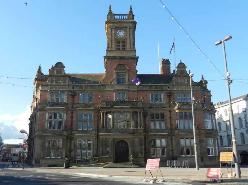
SD 33 NW BLACKPOOL TALBOT SQUARE
2/25 Town Hall
11.1. 1974 [formerly listed as Town Hall (excluding
extension to rear)]
II
Town Hall, 1895-1900, by Rotts Son and Hennings. Brick with stone dressings and
slate roofs. U-shape plan with receding wings. 3-storeys, right wing 2-storeys.
Jacobean style. Symmetrical front of 5 bays with central tower; central 2-storey
stone entrance porch in Tuscan order at ground floor, Ionic above, with segmental
pediment, and balustrade with corner finials. Ground floor of stone with continuous
entablature; four 6-light mullioned and transomed windows, the outer ones being
shallow rectangular bays surmounted by corner finials on the entablature.
1st floor has similar windows, the outer ones being shallow bays with curved corners,
and all have scrolled pediments in the entablature; 2nd floor has mullioned windows
with sashes. Outer bays rise to stone gabled attics with niches, entablature,
pediments, and finials; centre bay rises to clock tower of 2 stages, the lower
(of brick) containing a window with stone segmental-pedimented architrave, and bearing
a dentillated cornice surmounted by a stone belfry with coupled pilasters, cornice,
and balustrade with finials. (This was originally topped by a tall fleche).
Facade and right wing are hinged on a curved 2-storey stone bay with domical roof
set in concave re-entrant above. Left wing: 3rd bay with arched stone entrance and
corbelled 1st floor oriel, rises to square attic turret with stone cornice and
parapet surmounted by finials with open scrolled brackets; 4th bay has tall round-headed
and traceried 1st floor window, and a shaped stone gable with finials. Right wing:
2 storeys, the lower shops, the upper the Council Chamber with 4 tall oriels set in
round arches, steeply pitched roof surmounted by belfry with domical lead cap;
this wing ends with one 3-storey bay with nipped roof, dated 1896.
Listing NGR: SD3066636342
External links are from the relevant listing authority and, where applicable, Wikidata. Wikidata IDs may be related buildings as well as this specific building. If you want to add or update a link, you will need to do so by editing the Wikidata entry.


Other nearby listed buildings
