Approximate Location Map
Large Map »
Latitude: 53.7133 / 53°42'47"N
Longitude: -2.6086 / 2°36'31"W
OS Eastings: 359926
OS Northings: 424270
OS Grid: SD599242
Mapcode National: GBR BT7H.1M
Mapcode Global: WH96Z.WXZP
Plus Code: 9C5VP97R+8G
Entry Name: Sundial Circa 5 Metres South of Church of St James
Listing Date: 30 January 1987
Grade: II
Source: Historic England
Source ID: 1072543
English Heritage Legacy ID: 184306
ID on this website: 101072543
Location: St James's Church, Brindle, Chorley, Lancashire, PR6
County: Lancashire
District: Chorley
Civil Parish: Brindle
Traditional County: Lancashire
Lieutenancy Area (Ceremonial County): Lancashire
Church of England Parish: Brindle St James
Church of England Diocese: Blackburn
Tagged with: Sundial
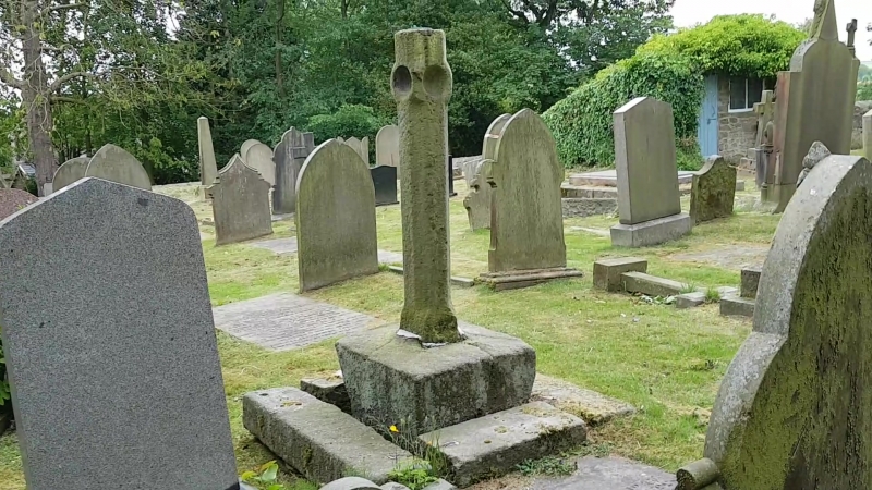
BRINDLE WATER STREET
SD 52 SE
5/55 Sundial c.5 metres south of
- Church of St. James
GV II
Sundial, probably C18. Stone. Square based, slim square pillar with
chamfered corners and near the top unusual saucer-shaped hollows in each side;
brass plate and scrolled gnomon.
Listing NGR: SD5992624270
External links are from the relevant listing authority and, where applicable, Wikidata. Wikidata IDs may be related buildings as well as this specific building. If you want to add or update a link, you will need to do so by editing the Wikidata entry.


Other nearby listed buildings
