Approximate Location Map
Large Map »
Latitude: 53.8465 / 53°50'47"N
Longitude: -2.9924 / 2°59'32"W
OS Eastings: 334806
OS Northings: 439369
OS Grid: SD348393
Mapcode National: GBR ZYK.SW
Mapcode Global: WH853.0LB3
Plus Code: 9C5VR2W5+H2
Entry Name: Whipping Post
Listing Date: 23 September 1950
Grade: II
Source: Historic England
Source ID: 1072407
English Heritage Legacy ID: 184786
ID on this website: 101072407
Location: Poulton-le-Fylde, Wyre, Lancashire, FY6
County: Lancashire
District: Wyre
Electoral Ward/Division: Tithebarn
Parish: Non Civil Parish
Built-Up Area: Poulton-le-Fylde
Traditional County: Lancashire
Lieutenancy Area (Ceremonial County): Lancashire
Church of England Parish: Poulton-le-Fylde St Chad
Church of England Diocese: Blackburn
Tagged with: Building
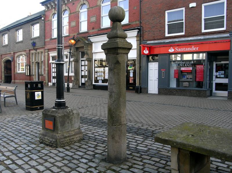
SD 33 NW MARKET PLACE
3/9
Whipping Post
23.9.50
GV II
Whipping Post, north side of Fish Stones, date uncertain. Stone column
with square cornice and ball finial.
Listing NGR: SD3480639369
External links are from the relevant listing authority and, where applicable, Wikidata. Wikidata IDs may be related buildings as well as this specific building. If you want to add or update a link, you will need to do so by editing the Wikidata entry.


Other nearby listed buildings
