Approximate Location Map
Large Map »
Latitude: 53.8982 / 53°53'53"N
Longitude: -2.7728 / 2°46'22"W
OS Eastings: 349314
OS Northings: 444949
OS Grid: SD493449
Mapcode National: GBR 9R2C.HB
Mapcode Global: WH850.C8VW
Plus Code: 9C5VV6XG+7V
Entry Name: Garstang Bridge
Listing Date: 16 December 1952
Last Amended: 9 January 1986
Grade: II
Source: Historic England
Source ID: 1072934
English Heritage Legacy ID: 185398
ID on this website: 101072934
Location: Bonds, Wyre, Lancashire, PR3
County: Lancashire
District: Wyre
Civil Parish: Barnacre-with-Bonds
Built-Up Area: Garstang
Traditional County: Lancashire
Lieutenancy Area (Ceremonial County): Lancashire
Church of England Parish: Garstang St Thomas
Church of England Diocese: Blackburn
Tagged with: Bridge
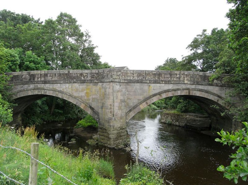
BARNACRE-WITH-BONDS BRIDGE STREET
SD 44 SE
7/11 Garstang Bridge (formerly listed as
Wyre Bridge, Garstang)
16.12.1952
- II
Bridge, early C19, widened on east side C20. Sandstone ashlar, 2 segmental
arches. Central triangular cutwaters, which have pedestrian refuges. Solid
parapets. Part of this bridge is in Garstang C.P. (q.v.)
Listing NGR: SD4931444949
External links are from the relevant listing authority and, where applicable, Wikidata. Wikidata IDs may be related buildings as well as this specific building. If you want to add or update a link, you will need to do so by editing the Wikidata entry.


Other nearby listed buildings
