Approximate Location Map
Large Map »
Latitude: 53.9372 / 53°56'13"N
Longitude: -2.7748 / 2°46'29"W
OS Eastings: 349234
OS Northings: 449287
OS Grid: SD492492
Mapcode National: GBR 9Q2X.2C
Mapcode Global: WH84T.B9XJ
Plus Code: 9C5VW6PG+V3
Entry Name: Milestone
Listing Date: 9 January 1986
Grade: II
Source: Historic England
Source ID: 1072918
English Heritage Legacy ID: 185427
ID on this website: 101072918
Location: Wyre, Lancashire, PR3
County: Lancashire
District: Wyre
Civil Parish: Cabus
Traditional County: Lancashire
Lieutenancy Area (Ceremonial County): Lancashire
Church of England Parish: Barnacre All Saints
Church of England Diocese: Blackburn
Tagged with: Milestone
CABUS A6
SD 44 NE
4/40 Milestone
-
- II
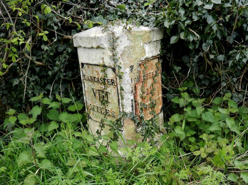
Milestone, C19. Sandstone with cast iron plates. Triangular on plan above
semi-circular base inscribed: 'CABUS'. Left-hand plate inscribed:
'LANCASTER VII MILES'. Right-hand plate inscribed: 'GARSTANG 2 1/4 MILES'.
Listing NGR: SD4923449287
External links are from the relevant listing authority and, where applicable, Wikidata. Wikidata IDs may be related buildings as well as this specific building. If you want to add or update a link, you will need to do so by editing the Wikidata entry.


Other nearby listed buildings
